Costa Rica Volcanoes
-
Poas
-
Poas
-
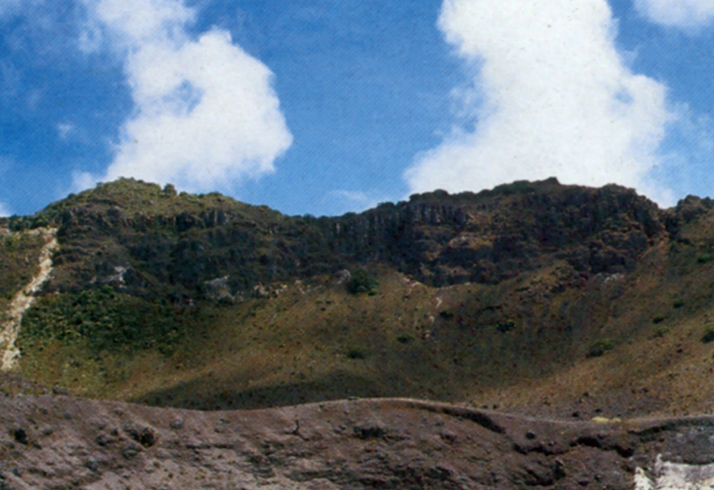
Rincon de la Vieja
-
Poas
-
Irazu
-
Poas
-
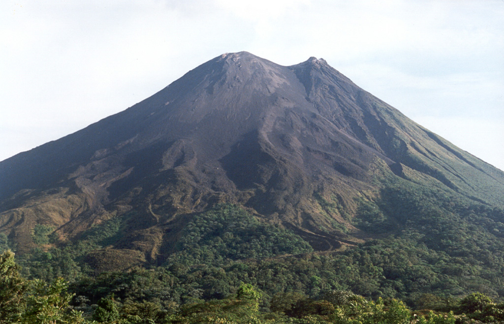
Arenal
-
Arenal
-
Orosi
-
Arenal
-

Arenal
-
Miravalles
-

Arenal
-
Irazu
-
Irazu
-
Turrialba
-
Miravalles
-
Arenal
-
Miravalles
-
Miravalles
Costa Rica has 10 Holocene volcanoes. Note that as a scientific organization we provide these listings for informational purposes only, with no international legal or policy implications. Volcanoes will be included on this list if they are within the boundaries of a country, on a shared boundary or area, in a remote territory, or within a maritime Exclusive Economic Zone. Bolded volcanoes have erupted within the past 20 years. Suggestions and data updates are always welcome ().
| Volcano Name | Location | Last Eruption | Primary Volcano Type |
|---|---|---|---|
| Arenal | Costa Rica | 2010 CE | Stratovolcano |
| Barva | Costa Rica | 6050 BCE | Complex |
| Irazu | Costa Rica | 1977 CE | Stratovolcano |
| Miravalles | Costa Rica | 1946 CE | Stratovolcano |
| Orosi | Costa Rica | Unknown - Evidence Uncertain | Stratovolcano(es) |
| Platanar | Costa Rica | Unknown - Evidence Credible | Stratovolcano(es) |
| Poas | Costa Rica | 2024 CE | Stratovolcano |
| Rincon de la Vieja | Costa Rica | 2024 CE | Complex |
| Tenorio | Costa Rica | Unknown - Evidence Credible | Stratovolcano(es) |
| Turrialba | Costa Rica | 2022 CE | Stratovolcano |
Chronological listing of known Holocene eruptions (confirmed or uncertain) from volcanoes in Costa Rica. Bolded eruptions indicate continuing activity.
| Volcano Name | Start Date | Stop Date | Certainty | VEI | Evidence |
|---|---|---|---|---|---|
| Poas | 2023 Dec 1 | 2024 Apr 19 (continuing) | Confirmed | Observations: Reported | |
| Poas | 2023 Aug 2 | 2023 Aug 11 | Confirmed | Observations: Reported | |
| Turrialba | 2022 Jul 17 | 2022 Jul 17 | Confirmed | 1 | Observations: Reported |
| Poas | 2022 Apr 6 | 2022 Apr 6 | Confirmed | 1 | Observations: Reported |
| Turrialba | 2021 Nov 3 | 2022 Feb 28 | Confirmed | 1 | Observations: Reported |
| Rincon de la Vieja | 2021 Jun 28 | 2024 Apr 19 (continuing) | Confirmed | 2 | Observations: Reported |
| Turrialba | 2021 Jun 13 | 2021 Jul 23 | Confirmed | 1 | Observations: Reported |
| Turrialba | 2020 Jun 18 | 2020 Aug 24 | Confirmed | 1 | Observations: Reported |
| Rincon de la Vieja | 2020 Jan 30 | 2020 Dec 13 | Confirmed | 2 | Observations: Reported |
| Poas | 2019 Feb 7 | 2019 Sep 30 | Confirmed | 2 | Observations: Reported |
| Rincon de la Vieja | 2018 Jul 28 | 2019 Jun 11 | Confirmed | 1 | Observations: Reported |
| Rincon de la Vieja | 2017 May 23 | 2018 Mar 15 ± 3 days | Confirmed | 1 | Observations: Reported |
| Poas | 2017 Apr 12 | 2017 Nov 6 | Confirmed | 1 | Observations: Reported |
| Poas | 2016 Jun 5 | 2016 Aug 16 | Confirmed | 1 | Observations: Reported |
| Rincon de la Vieja | 2015 Jun 16 | 2016 May 1 | Confirmed | 1 | Observations: Reported |
| Turrialba | 2015 Mar 8 | 2019 Dec 7 | Confirmed | 3 | Observations: Reported |
| Turrialba | 2014 Oct 29 | 2014 Dec 8 | Confirmed | 2 | Observations: Reported |
| Rincon de la Vieja | 2014 Sep 17 | 2014 Oct 24 | Confirmed | 1 | Observations: Reported |
| Turrialba | 2013 May 21 | 2013 Jun 4 | Confirmed | 2 | Observations: Reported |
| Rincon de la Vieja | 2012 Oct 17 | 2012 Oct 17 | Confirmed | 1 | Observations: Reported |
| Rincon de la Vieja | 2012 Feb 19 | 2012 Apr 14 | Confirmed | 1 | Observations: Reported |
| Turrialba | 2012 Jan 12 | 2012 Jan 18 | Confirmed | 2 | Observations: Reported |
| Rincon de la Vieja | 2011 Aug 22 | 2011 Sep 27 | Confirmed | 1 | Observations: Reported |
| Turrialba | 2011 Jan 14 | 2011 Jan 14 | Confirmed | 1 | Observations: Reported |
| Turrialba | [2010 Jul 24] | [2010 Aug 15] | Uncertain | ||
| Turrialba | 2010 Jan 5 | 2010 Mar 7 (?) | Confirmed | 2 | Observations: Reported |
| Poas | 2009 Nov 16 ± 15 days | 2014 Oct 13 | Confirmed | 1 | Observations: Reported |
| Poas | 2009 Jan 12 | 2009 Mar 21 (?) | Confirmed | 1 | Observations: Reported |
| Poas | 2008 Jan 13 | 2008 Jan 13 | Confirmed | 1 | Observations: Reported |
| Poas | 2006 Sep 25 | 2006 Dec 16 | Confirmed | 1 | Observations: Reported |
| Poas | 2006 Mar 24 | 2006 Mar 24 (?) | Confirmed | 1 | Observations: Reported |
| Rincon de la Vieja | 1998 Feb 15 | 1998 Sep 16 ± 15 days | Confirmed | 2 | Observations: Reported |
| Poas | 1996 Apr 8 | 1996 Apr 8 | Confirmed | 1 | Observations: Reported |
| Rincon de la Vieja | 1995 Nov 6 | 1995 Nov 13 | Confirmed | 2 | Observations: Reported |
| Irazu | [1994 Dec 8] | [1994 Dec 8] | Uncertain | ||
| Poas | 1994 Mar 16 (?) ± 15 days | 1994 Oct 16 (?) ± 15 days | Confirmed | 2 | Observations: Reported |
| Poas | 1992 Oct 16 ± 15 days | 1993 Sep 16 ± 15 days | Confirmed | 0 | Observations: Reported |
| Poas | 1992 Feb 16 ± 15 days | 1992 Mar 16 ± 15 days | Confirmed | 1 | Observations: Reported |
| Rincon de la Vieja | 1991 May 7 | 1992 Sep 16 ± 15 days | Confirmed | 2 | Observations: Reported |
| Poas | 1991 Mar 6 | 1991 Sep 16 ± 15 days | Confirmed | 1 | Observations: Reported |
| Poas | 1987 Jun 16 ± 15 days | 1990 Jun 16 ± 15 days | Confirmed | 2 | Observations: Reported |
| Rincon de la Vieja | 1987 Apr 1 | 1987 Apr 1 | Confirmed | 1 | Observations: Reported |
| Rincon de la Vieja | 1986 Dec 31 | 1986 Dec 31 | Confirmed | 1 | Observations: Reported |
| Rincon de la Vieja | 1985 Sep 16 ± 15 days | 1986 Apr 16 ± 15 days | Confirmed | 1 | Observations: Reported |
| Rincon de la Vieja | 1984 Mar 31 | 1984 Apr 16 ± 15 days | Confirmed | 2 | Observations: Reported |
| Rincon de la Vieja | 1983 Feb 6 | 1983 Feb 21 | Confirmed | 1 | Observations: Reported |
| Poas | 1981 Mar 16 ± 15 days | 1981 May 16 ± 15 days | Confirmed | 1 | Observations: Reported |
| Poas | 1980 Dec 26 | 1980 Dec 26 | Confirmed | 1 | Observations: Reported |
| Poas | 1980 Sep 12 | 1980 Sep 12 | Confirmed | 1 | Observations: Reported |
| Poas | 1979 Sep 8 | 1980 Jan 16 ± 15 days | Confirmed | 1 | Observations: Reported |
| Poas | 1978 Sep 22 | 1978 Dec 16 ± 15 days | Confirmed | 1 | Observations: Reported |
| Poas | 1977 Dec 18 | 1978 Jun 15 | Confirmed | 2 | Observations: Reported |
| Poas | 1977 May 16 ± 15 days | 1977 Jul 16 (?) ± 15 days | Confirmed | 1 | Observations: Reported |
| Irazu | 1977 Mar 3 | Unknown | Confirmed | 1 | Observations: Reported |
| Poas | 1976 Jun 21 | 1976 Nov 16 ± 15 days | Confirmed | 2 | Observations: Reported |
| Poas | 1974 Sep 11 | 1975 Feb 16 ± 15 days | Confirmed | 2 | Observations: Reported |
| Poas | 1972 Feb 9 | 1973 Sep 8 | Confirmed | 2 | Observations: Reported |
| Rincon de la Vieja | 1970 Aug 14 | 1970 Aug 15 | Confirmed | 1 | Observations: Reported |
| Poas | 1970 Jul 16 ± 15 days | Unknown | Confirmed | 1 | Observations: Reported |
| Rincon de la Vieja | 1969 Sep 20 | 1969 Oct 16 | Confirmed | 2 | Observations: Reported |
| Poas | 1969 May 3 | 1969 Jun 3 | Confirmed | 2 | Observations: Reported |
| Rincon de la Vieja | 1969 Apr 22 | 1969 May 16 ± 15 days | Confirmed | 2 | Observations: Reported |
| Arenal | 1968 Jul 29 | 2010 Dec 16 (?) ± 15 days | Confirmed | 3 | Observations: Reported |
| Poas | 1968 Jul 2 ± 182 days | Unknown | Confirmed | 1 | Observations: Reported |
| Poas | 1967 Jan 1 | Unknown | Confirmed | 1 | Observations: Reported |
| Rincon de la Vieja | 1966 Nov 6 (?) | 1967 Dec 16 ± 15 days | Confirmed | 3 | Observations: Reported |
| Poas | 1964 Dec 25 | 1965 Mar 16 ± 15 days | Confirmed | 2 | Observations: Reported |
| Poas | 1963 May 23 | 1963 Jul 2 | Confirmed | 2 | Observations: Reported |
| Irazu | 1963 Mar 13 | 1965 Feb 13 | Confirmed | 3 | Observations: Reported |
| Poas | 1958 Jul 2 ± 182 days | 1961 Jul 3 (?) | Confirmed | 2 | Observations: Reported |
| Poas | 1952 Mar 23 | 1957 Dec 25 | Confirmed | 2 | Observations: Reported |
| Poas | 1948 | 1951 Jul 2 ± 182 days | Confirmed | 1 | Observations: Reported |
| Poas | 1946 Nov 4 ± 4 days | Unknown | Confirmed | 1 | Observations: Reported |
| Miravalles | 1946 Sep 14 | 1946 Sep 14 | Confirmed | 1 | Observations: Reported |
| Poas | 1941 | 1946 | Confirmed | 1 | Observations: Reported |
| Irazu | 1939 May 18 | 1940 Feb | Confirmed | 2 | Observations: Reported |
| Irazu | 1933 Mar 22 (?) | 1933 Jul 25 | Confirmed | 2 | Observations: Reported |
| Poas | 1932 | 1934 | Confirmed | 1 | Observations: Reported |
| Irazu | 1930 Oct | Unknown | Confirmed | 2 | Observations: Reported |
| Poas | 1929 | Unknown | Confirmed | 1 | Observations: Reported |
| Irazu | 1928 Feb 14 | 1928 May 26 ± 5 days | Confirmed | 2 | Observations: Reported |
| Poas | 1925 | Unknown | Confirmed | 1 | Observations: Reported |
| Irazu | 1924 Mar | 1924 Apr | Confirmed | 2 | Observations: Reported |
| Arenal | 1922 Oct 5 (?) | 1922 Oct 23 (?) | Confirmed | 2 | Observations: Reported |
| Rincon de la Vieja | 1922 Apr 11 (in or before) | 1922 Jun 4 | Confirmed | 2 | Observations: Reported |
| Irazu | 1917 Sep 27 | 1921 | Confirmed | 3 | Observations: Reported |
| Rincon de la Vieja | [1917] | [Unknown] | Uncertain | ||
| Poas | 1916 | Unknown | Confirmed | 2 | Observations: Reported |
| Arenal | [1915 Feb 5] | [Unknown] | Uncertain | ||
| Poas | 1914 Oct 8 | 1915 May 15 (in or after) | Confirmed | 2 | Observations: Reported |
| Poas | 1914 May 30 | Unknown | Confirmed | 2 | Observations: Reported |
| Irazu | [1914 Feb 21] | [Unknown] | Uncertain | ||
| Rincon de la Vieja | 1912 Jun 14 | Unknown | Confirmed | 3 | Observations: Reported |
| Poas | 1910 Sep 12 | 1910 Oct 14 | Confirmed | 1 | Observations: Reported |
| Poas | 1910 Jan 25 | 1910 Feb | Confirmed | 2 | Observations: Reported |
| Irazu | [1909] | [Unknown] | Uncertain | ||
| Rincon de la Vieja | [1902 Jun 22] | [Unknown] | Uncertain | ||
| Poas | 1898 Dec 29 | 1907 Dec 31 ± 365 days | Confirmed | 1 | Observations: Reported |
| Poas | 1895 | Unknown | Confirmed | 1 | Observations: Reported |
| Poas | 1888 Jan | 1891 | Confirmed | 1 | Observations: Reported |
| Irazu | 1886 | Unknown | Confirmed | 2 | Observations: Reported |
| Irazu | 1885 | Unknown | Confirmed | 2 | Observations: Reported |
| Irazu | [1882] | [Unknown] | Uncertain | ||
| Poas | 1880 | Unknown | Confirmed | 1 | Observations: Reported |
| Poas | [1879] | [Unknown] | Uncertain | ||
| Irazu | 1875 ± 5 years | Unknown | Confirmed | 2 | Observations: Reported |
| Barva | [1867 Mar] | [Unknown] | Uncertain | ||
| Turrialba | 1866 Jan | 1866 May 8 | Confirmed | 3 | Observations: Reported |
| Irazu | 1864 Sep 16 | 1864 Sep 17 | Confirmed | 2 | Observations: Reported |
| Turrialba | 1864 Aug 17 | 1865 Mar | Confirmed | 2 | Observations: Reported |
| Turrialba | [1861] | [Unknown] | Uncertain | ||
| Poas | 1860 | Unknown | Confirmed | 1 | Observations: Reported |
| Turrialba | 1855 May | Unknown | Confirmed | 2 | Observations: Reported |
| Rincon de la Vieja | 1854 | 1863 Aug | Confirmed | 2 | Observations: Reported |
| Rincon de la Vieja | 1853 | Unknown | Confirmed | 2 | Observations: Reported |
| Turrialba | 1853 | Unknown | Confirmed | 2 | Observations: Reported |
| Rincon de la Vieja | [1851] | [Unknown] | Uncertain | ||
| Rincon de la Vieja | 1849 | Unknown | Confirmed | 2 | Unknown |
| Irazu | 1847 May 18 | Unknown | Confirmed | 2 | Observations: Reported |
| Turrialba | [1847] | [Unknown] | Uncertain | ||
| Rincon de la Vieja | 1844 May | Unknown | Confirmed | 2 | Unknown |
| Irazu | [1844 May] | [Unknown] | Uncertain | ||
| Irazu | 1842 | Unknown | Confirmed | 2 | Observations: Reported |
| Poas | [1838] | [Unknown] | Uncertain | ||
| Poas | 1834 | Unknown | Confirmed | 2 | Observations: Reported |
| Poas | 1828 | Unknown | Confirmed | 1 | Observations: Reported |
| Irazu | [1826] | [Unknown] | Uncertain | ||
| Irazu | 1823 | Unknown | Confirmed | 2 | Observations: Reported |
| Irazu | 1822 May 7 | Unknown | Confirmed | 2 | Observations: Reported |
| Irazu | [1821 May] | [Unknown] | Uncertain | ||
| Irazu | 1775 (?) | Unknown | Confirmed | 2 | Observations: Reported |
| Rincon de la Vieja | 1765 | Unknown | Confirmed | 2 | Observations: Reported |
| Arenal | 1750 ± 50 years | Unknown | Confirmed | 0 | Correlation: Tephrochronology |
| Poas | 1747 | Unknown | Confirmed | 2 | Observations: Reported |
| Irazu | 1726 May | Unknown | Confirmed | 2 | Observations: Reported |
| Irazu | 1723 Feb 16 | 1724 Feb (?) | Confirmed | 3 | Observations: Reported |
| Turrialba | [1723] | [Unknown] | Uncertain | ||
| Irazu | 1560 ± 75 years | Unknown | Confirmed | 3 | Isotopic: 14C (calibrated) |
| Rincon de la Vieja | [1529] | [Unknown] | Uncertain | ||
| Arenal | 1440 (?) | Unknown | Confirmed | 2 | Isotopic: 14C (uncalibrated) |
| Arenal | 1400 (?) | Unknown | Confirmed | 4 | Isotopic: 14C (uncalibrated) |
| Turrialba | 1350 (?) | Unknown | Confirmed | Isotopic: 14C (uncalibrated) | |
| Poas | 1280 (?) | Unknown | Confirmed | Correlation: Tephrochronology | |
| Irazu | 1110 ± 100 years | Unknown | Confirmed | 3 | Isotopic: 14C (calibrated) |
| Arenal | 1030 (?) | Unknown | Confirmed | 4 | Correlation: Tephrochronology |
| Arenal | 1020 (?) | Unknown | Confirmed | 4 | Correlation: Tephrochronology |
| Arenal | 0750 ± 50 years | Unknown | Confirmed | 4 | Correlation: Anthropology |
| Arenal | 0700 (?) | Unknown | Confirmed | 4 | Correlation: Tephrochronology |
| Irazu | 0690 ± 40 years | Unknown | Confirmed | 3 | Isotopic: 14C (calibrated) |
| Arenal | 0650 ± 100 years | Unknown | Confirmed | 4 | Isotopic: 14C (calibrated) |
| Turrialba | 0640 ± 40 years | Unknown | Confirmed | Isotopic: 14C (calibrated) | |
| Arenal | 0550 (?) | Unknown | Confirmed | 4 | Correlation: Tephrochronology |
| Rincon de la Vieja | 0430 ± 100 years | Unknown | Confirmed | Isotopic: 14C (calibrated) | |
| Irazu | 0430 ± 500 years | Unknown | Confirmed | 3 | Isotopic: 14C (calibrated) |
| Arenal | 0400 (?) | Unknown | Confirmed | 4 | Correlation: Anthropology |
| Poas | 0210 (?) | Unknown | Confirmed | Correlation: Tephrochronology | |
| Turrialba | 0040 ± 50 years | Unknown | Confirmed | 4 | Isotopic: 14C (calibrated) |
| Arenal | 0170 BCE ± 200 years | Unknown | Confirmed | 4 | Isotopic: 14C (calibrated) |
| Arenal | 0270 BCE (?) | Unknown | Confirmed | 4 | Correlation: Tephrochronology |
| Arenal | 0380 BCE ± 200 years | Unknown | Confirmed | 4 | Isotopic: 14C (calibrated) |
| Irazu | 0640 BCE ± 500 years | Unknown | Confirmed | 3 | Isotopic: 14C (calibrated) |
| Poas | 0760 BCE ± 200 years | Unknown | Confirmed | Isotopic: 14C (calibrated) | |
| Arenal | 0830 BCE ± 500 years | Unknown | Confirmed | 0 | Correlation: Tephrochronology |
| Turrialba | 0830 BCE ± 150 years | Unknown | Confirmed | Isotopic: 14C (calibrated) | |
| Turrialba | 1120 BCE ± 200 years | Unknown | Confirmed | Correlation: Tephrochronology | |
| Arenal | 1250 BCE ± 200 years | Unknown | Confirmed | 4 | Isotopic: 14C (calibrated) |
| Turrialba | 1420 BCE ± 300 years | Unknown | Confirmed | Isotopic: 14C (calibrated) | |
| Arenal | 1450 BCE (?) | Unknown | Confirmed | 4 | Correlation: Tephrochronology |
| Arenal | 1650 BCE (?) | Unknown | Confirmed | 4 | Correlation: Tephrochronology |
| Arenal | 1770 BCE ± 100 years | Unknown | Confirmed | Isotopic: 14C (calibrated) | |
| Rincon de la Vieja | 1820 BCE ± 150 years | Unknown | Confirmed | 4 | Isotopic: 14C (calibrated) |
| Arenal | 2250 BCE (?) | Unknown | Confirmed | 4 | Correlation: Tephrochronology |
| Arenal | 2800 BCE (?) | Unknown | Confirmed | 4 | Correlation: Tephrochronology |
| Arenal | 3190 BCE ± 100 years | Unknown | Confirmed | Isotopic: 14C (uncalibrated) | |
| Arenal | 3350 BCE (?) | Unknown | Confirmed | 4 | Correlation: Tephrochronology |
| Arenal | 3900 BCE (?) | Unknown | Confirmed | 4 | Correlation: Tephrochronology |
| Poas | 3950 BCE (?) | Unknown | Confirmed | Isotopic: 14C (calibrated) | |
| Arenal | 4450 BCE (?) | Unknown | Confirmed | Correlation: Tephrochronology | |
| Miravalles | 5050 BCE (?) | Unknown | Confirmed | Correlation: Tephrochronology | |
| Arenal | 5060 BCE ± 150 years | Unknown | Confirmed | 4 | Isotopic: 14C (calibrated) |
| Poas | 5590 BCE ± 100 years | Unknown | Confirmed | Isotopic: 14C (uncalibrated) | |
| Barva | 6050 BCE ± 2000 years | Unknown | Confirmed | 4 | Correlation: Tephrochronology |
| Turrialba | 7260 BCE ± 300 years | Unknown | Confirmed | Isotopic: 14C (calibrated) | |
| Poas | 7620 BCE ± 100 years | Unknown | Confirmed | Isotopic: 14C (uncalibrated) | |
| Poas | 7920 BCE ± 75 years | Unknown | Confirmed | Isotopic: 14C (uncalibrated) |
Costa Rica has 12 Pleistocene volcanoes. Note that as a scientific organization we provide these listings for informational purposes only, with no international legal or policy implications. Volcanoes will be included on this list if they are within the boundaries of a country, on a shared boundary or area, in a remote territory, or within a maritime Exclusive Economic Zone. Suggestions and data updates are always welcome ().
| Volcano Name | Location | Primary Volcano Type |
|---|---|---|
| Cerro Chopo | Costa Rica | Pyroclastic cone |
| Isla del Coco | Costa Rica | Shield |
| Lomas de Colorado | Costa Rica | Shield(s) |
| Durika | Costa Rica | Lava dome(s) |
| Cerro las Mercedes | Costa Rica | Pyroclastic cone |
| Cerro Negro | Costa Rica | Shield |
| Los Perdidos | Costa Rica | Caldera |
| Laguna Poco Sol | Costa Rica | Explosion crater(?) |
| Cerro San Miguel | Costa Rica | Lava dome |
| Lomas de Sierpe | Costa Rica | Shield(s) |
| Cerro Tilaran | Costa Rica | Shield |
| Tortuguero | Costa Rica | Pyroclastic cone |
There are 191 photos available for volcanoes in Costa Rica.
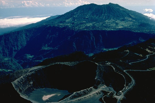
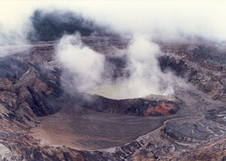
 The broad massif of Poás volcano rises about 35 km to the NW above the outskirts of the city of San José. The summit of the volcano is a national park and is easily accessible by road from the capital city. The massive 2708-m-high volcano covers an area of about 300 km2 and rises about 1400 m above the central valley. Two large calderas cut its summit, and an acidic crater lake partially fills the active crater.
Photo by Ichio Moriya (Kanazawa University).
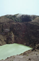
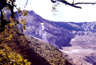
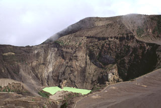
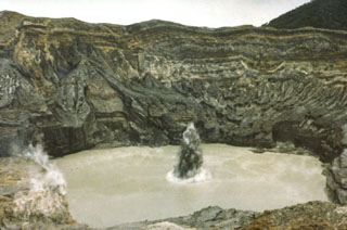
 A lake occupies one of the Irazú summit craters (seen here from the southern crater rim in 1996), which has been the source of many recent eruptions. The first well-documented eruption of Irazú occurred in 1723, and frequent explosive eruptions have occurred since. Ashfall from its last major eruption during 1963-65 caused significant disruption to San José and surrounding areas.
Photo by José Enrique Valverde Sanabria, 1996 (courtesy of Eduardo Malavassi, OVSICORI-UNA).
 The two main summit craters of Irazú are seen here from the west in 1998. A lake fills the bottom of the main crater (Cráter Principal), with the older Diego de la Haya crater at the top of the photo.
 Photo by Paul Kimberly, 1998 (Smithsonian Institution).
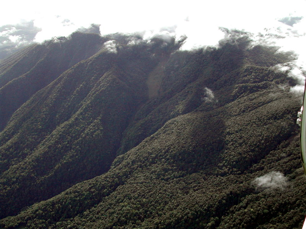
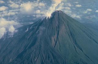
 Poás is a broad volcano with a summit area containing three craters and is one of the most active volcanoes of Costa Rica. This photo from the east shows a plume rising from the active summit crater, which has been the site of frequent phreatic and phreatomagmatic eruptions since 1828, and the lake filled Botos crater to the left.
 Photo by Mike Carr (Rutgers University).
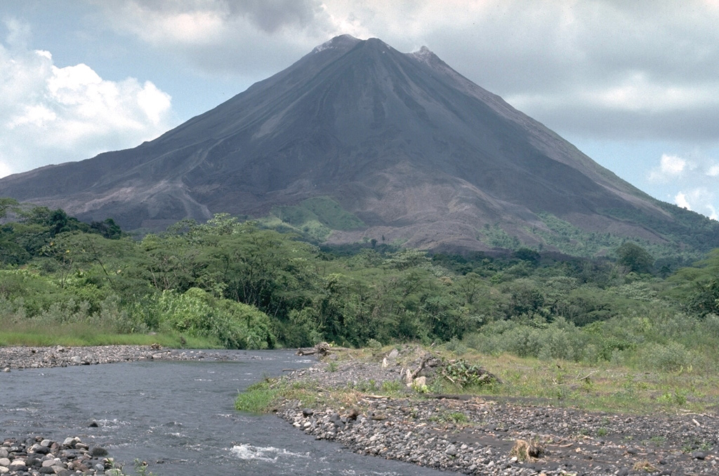
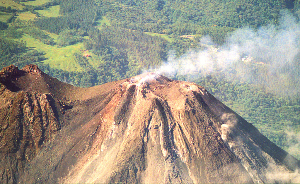
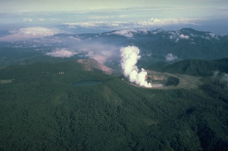
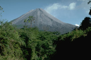
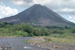
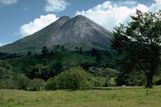
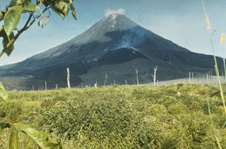
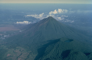
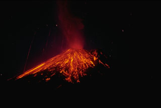
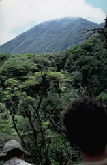
 The symmetrical Volcán Arenal is the youngest stratovolcano in Costa Rica and one of its most active. Steam rises from lava flows descending the west flank in this March 1983 view. The oldest known products of Arenal volcano are only about 7000 years old. Arenal's most recent eruptive period began with a major explosion in 1968. Continuous explosive activity accompanied by slow lava effusion has occurred since from vents at the summit and western flank.
 Copyrighted photo by Katia and Maurice Krafft, 1983.
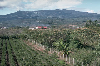
 Arenal towers above forests along the Río Agua Caliente on the WSW flank. The Volcán Arenal National Park lies within the Arenal Conservation Area, which combines to protect eight of Costa Rica's 12 biological life zones and includes 16 protected reserves.
Photo by William Melson, 1990 (Smithsonian Institution).
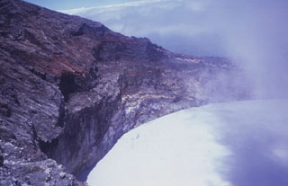
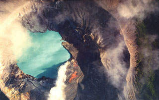
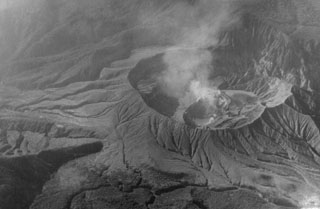
 The degassing Poás crater, seen here in an aerial view from the NE, lies within the smaller of two nested calderas at the summit. This inner caldera is 4 km in diameter. A tourist overlook along the ESE crater rim near the upper left provides a view into the crater.
Photo by National Aeronautics and Space Administration (NASA), 1982.
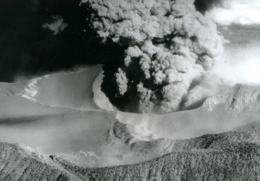
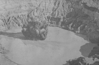
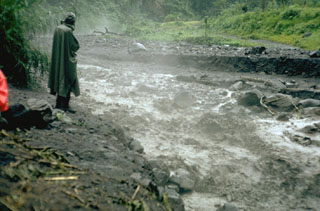
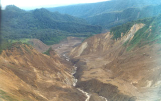 An avalanche produced during an 8 December 1994 phreatic explosion at Irazú traveled down the Río Sucio to the north, destroying trees high up the banks of the river. Associated lahars swept many kilometers farther down the river, which flows through the Cordillera Volcánica Central Forest Reserve. The explosion formed a new crater in a geothermal area north of the main crater.
Photo by Jorge Barquero, 1998 (OVSICORI-UNA).
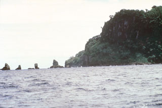 Erosional remnants of the widespread pyroclastic rock unit at the NW corner of Cocos Island form small offshore islets. Pyroclastic rock units are thickest at the NE side of the island, south of the large trachytic lava dome between Bahia Wafer and Bahia Chathan, but are also exposed along the NW, SW, and southern coasts, and in the SW and eastern interior of the island.
Photo by Pat Castillo, 1984 (Scripps Institution of Oceanography, University of California San Diego).
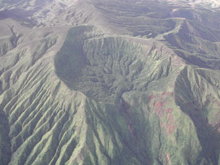
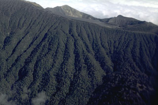 The upper southern flanks of Irazú contain abundant erosional gullies. The summit is just out of view at the upper right. The northern rim of the currently active summit crater is at the top of this photo, in the center. To the right is the northern rim of the older Diego de la Haya crater.
 Photo by William Melson, 1986 (Smithsonian Institution).
 An ash plume rises above the crater lake of Poás volcano in 1915. Intermittent eruptions producing ashfall during 8 October 1914 to 15 May 1915. The 10 April eruption was seen from San José, and the last of a series of eruptions during 15-19 April that produced ashfall across great distances.
Photo by R. Fernandez Peralta, 1915 (courtesy of Jorge Barquero, Universidad Nacional Costa Rica).
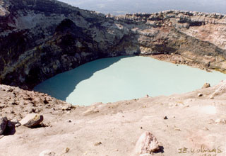
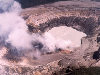
 The degassing crater lake at the summit of Poás volcano is seen here in 1982. The 800-m-wide crater lies near the center of the smaller of two calderas at the summit. One of the world’s most acidic natural lakes, the diameter and depth varies with seasonal rainfall and eruptive activity; on occasion the lake has disappeared.
 Photo by Bill Rose, 1982 (Michigan Technological University).
 This 1992 view from the SW looks towards Arenal with the new active summit crater just right of the pre-1968 summit, the high point to the left. The 1968-onwards eruption constructed the new cone to the west of the crater from the previous major eruption in about 1525 CE. Lava flows from this eruption cover the unvegetated lower western and southern flanks.
 Photo by William Melson, 1992 (Smithsonian Institution)
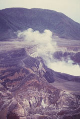
 This view of the less-frequently seen northern side of Irazú's summit crater complex shows fumaroles rising from vents below a steep escarpment cutting the outer NW flank of the volcano's main crater (which lies behind the high point on the left horizon). This thermal area, known as Las Fumaroles, was the source of an explosive eruption in December 1994 that also produced an avalanche and mudflow down the Río Sucio, the valley at the lower right.
Photo by Jorge Barquero, 1994 (Universidad Nacional Costa Rica).
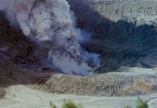
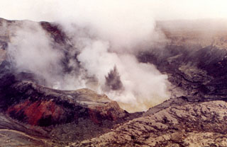
 An ejection of steam and ash rises above the surface of the crater lake of Poás volcano in July 1977. The white ring at the base of the eruption plume is a steam cloud that is traveling along the surface of the lake. Mild phreatic explosions such as this one were typical of the eruption that began in May 1977 and lasted at least until July. The crater walls rise about 250 m above the lake.
Photo by S. Racchini, 1977 (Universidad Nacional Costa Rica, courtesy of Jorge Barquero).
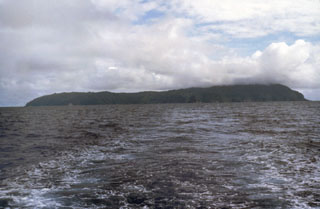 The low profile of Isla del Coco is seen from the NE, taken from the R/V Searcher of the University of Costa Rica. The 22 km2 rain-drenched island was discovered by the Spanish pilot Juan Cabezas around 1526 CE, and the Costa Rican flag was first planted on the island in 1869. Isla del Coco is the only subaerial portion of the Cocos Ridge, which extends from the Galápagos hot spot to the Mesoamerican trench. Construction of a Pliocene-Pleistocene shield volcano was followed by caldera formation and the emplacement of a trachytic lava dome.
Photo by Pat Castillo, 1984 (Scripps Institution of Oceanography, University of California San Diego).
 Ash plumes rise above vents in the Poás summit crater on 4 May 1990, near the end of an eruptive period that began in June 1987. At the time of this photo the crater lake had shrunk substantially to only several centimeters deep that fluctuated slightly with changes in rainfall recharge. Lake temperatures were over 72°C (measured by infrared thermometer), and small hot springs around the lake had temperatures of 85°C. Minor explosive eruptions continued into the following month.
 Photo by Jorge Barquero, 1990 (Universidad Nacional Costa Rica).
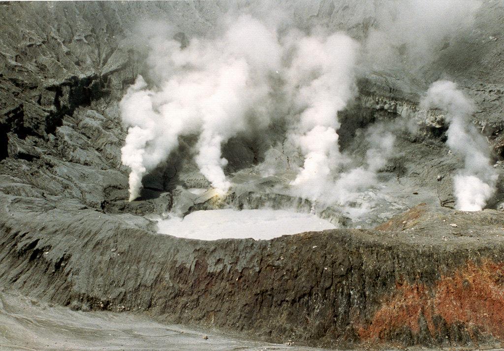
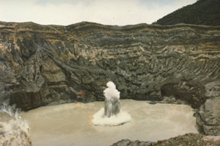
 The crater lake of the Cráter Activo of Rincón de la Vieja is seen here on 2 April 1998 from its eastern rim during the 1998 eruption. The eruption began with phreatic explosions during 15-18 February that produced steam plumes up to 2 km above the crater lake, and scorched vegetation on the NE side of the crater. On 16 February a lahar traveled around 12 km down the Penjamo and Azul rivers. Twenty explosions were recognized from seismic records, and additional explosions were recorded in May, June, and September.
 Photo by José Enrique Valverde Sanábria, 1998 (courtesy of Eduardo Malavassi, OVSICORI-UNA).
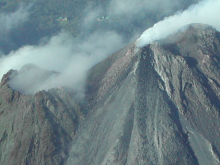 Gas emissions rise from the active Arenal summit crater (Crater C, upper right) in 2003, and a lava flow descends the NE flank to the bottom of the image. Some fumarolic activity is occurring from the pre-1968 crater (Crater D, left). The building at the top left is the Arenal Volcano Observatory.
Photo by Eliecer Duarte, 2003 (OVSICORI-UNA).
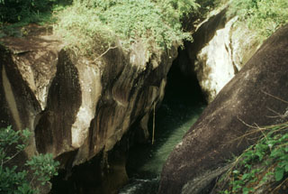
 Geologist Eric Fernandez examines an outcrop of pyroclastic rocks along the banks of the Río Genio, on the northern side of Cocos Island. Pyroclastic rocks were erupted either immediately prior to or contemporaneously with trachytic rocks forming a lava dome. Pyroclastic rocks are thickest on the northern side of the island, which may represent the topographic high of the old seamount.
Photo by Pat Castillo, 1984 (Scripps Institution of Oceanography, University of California San Diego).
 This 1964 photo shows visitors at the edge of the Irazú active crater; seven people were killed and many more injured by explosive ejecta in April and August of that year. Secondary lahars produced by the remobilization of thick ash deposits also caused fatalities. Over a 2-year period, 46 lahars occurred along the Río Reventado valley; one killed at least 20 people and destroyed 400 houses and some factories.
Anonymous, 1964 (published in Alvarado, 1989).
 Vegetation covers overlapping lava flows that descend the NE flank of the Tenorio volcanic complex. The summit of Volcán Tenorio, the highest peak of the complex, has two small craters.
Photo by William Melson, 1985 (Smithsonian Institution).
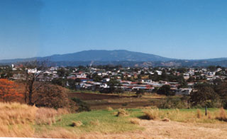
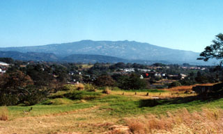 Barva volcano (also spelled Barba) rises to the NE above the western outskirts of San José. The volcano lies about 22 km north of the city. Three peaks along the broad summit ridge give rise to the name Las Tres Marías (The Three Marias). No confirmed historical eruptions are known from Barva, but thermal springs are found near Porrosati de Barva, Gongolona peak, and along ridges to the north side of the volcano. Sulfur vapor and mineral deposition occurs at landslide scarps on the flanks of the volcano.
Photo by Ichio Moriya (Kanazawa University).
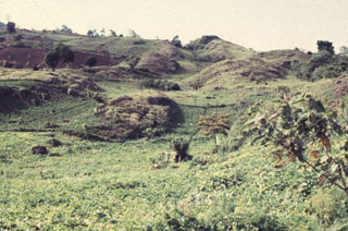
 The remote northern side of the youngest cone of the Miravalles volcanic complex is covered with dense rain forest. Prior to the arrival of the Spanish, Miravalles was known by indigenous people as Cuipilapa, a Nahuatl term meaning "river of many colors," a reference to minerals dissolved in rivers descending the volcano.
 Photo by Eliecer Duarte (OVSICORI-UNA).
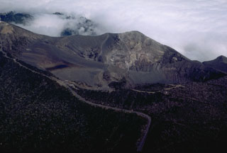
 The new post-1968 Arenal cone is to the right in this 1989 view from the NW. The pre-1968 summit forms the peak to the left. Eruptions originating from four craters on the western flank produced the new cone and a lava flow field on the lower western flank.
 Photo by William Melson, 1989 (Smithsonian Institution)
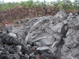
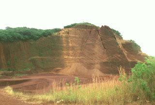 The interior of the Cerro Chopo pyroclastic cone has been exposed by extensive quarrying operations to provide aggregate materials for road construction. Reverse grading can be observed in walls produced by the quarrying. The cone rises about 250 m above its base to 402 m elevation. The crater is oriented to the NW and was the source of olivine-basaltic lava flows.
 Photo by Lee Siebert, 1998 (Smithsonian Institution).
 Poás erupted intermittently from June 1987 to June 1990, producing ash plumes such as this one seen on 6 March 1989. Phreatic explosions had resumed from June 1987 until at least October 1988, punctuated by large explosions on 9 April 1988. The crater lake completely disappeared by April 1989, and during May ash plumes reached heights of 1.5-2 km above the crater.
 Photo by Gerardo Soto, 1989 (Instituto Costarricense de Electricidad, published in Alvarado, 1989).
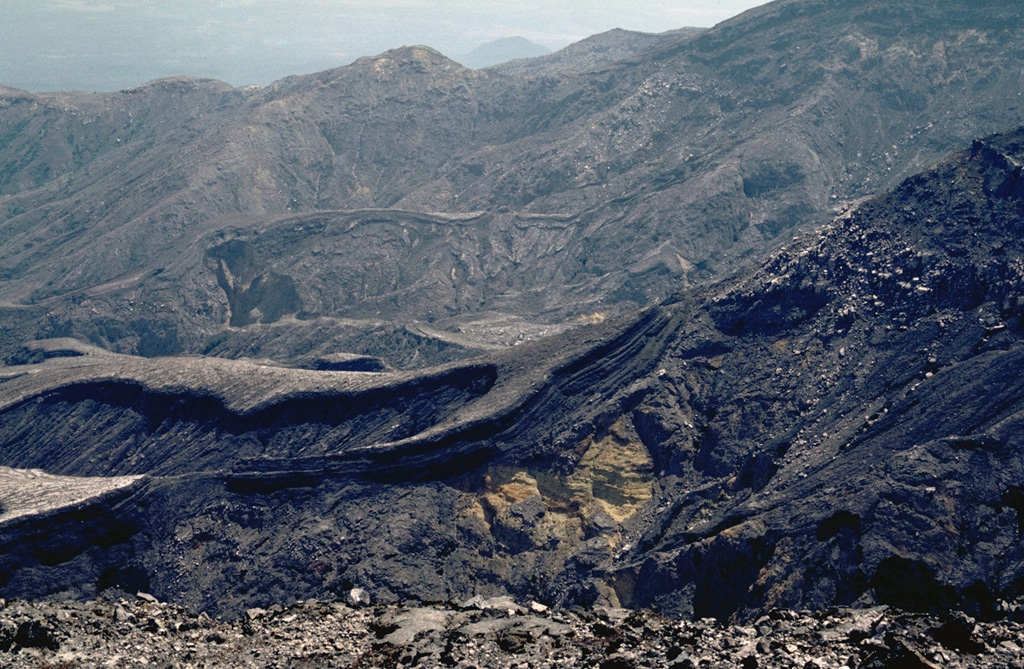
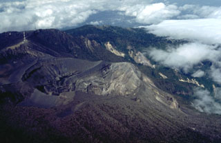
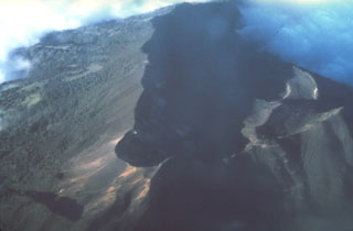 The summit crater complex of 3340-m-high Turrialba volcano appears in the shadow of this aerial view from the south. Three overlapping craters, each of which contains sub-craters, occur within the 2 x 4 km summit depression. A cloud bank at the upper right covers the breached NE end of the summit crater complex.
Photo by Stan Williams (Arizona State University, courtesy of Mike Carr, Rutgers University).
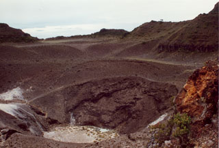
 This eroded crater lies near the western margin of Rincón de la Vieja, seen here from the SE. This roughly 1-km-wide crater is about 2 km W of Cráter Activo. On the lower left flank, steep erosional gullies have formed through erosion.
 Photo by Eliecer Duarte (OVSICORI-UNA).
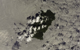 Clouds partially obscure the 22 km2 Isla del Coco (Cocos Island) in this NASA International Space Station image. Chathan Bay (top) lies off the NE tip of the island, which sits astride the Cocos Ridge about 650 km SW of the Costa Rican port of Puntarenas. The rain-drenched island is renowned as the site of treasures buried by pirates and ship captains. Construction of a Pliocene-Pleistocene shield volcano was followed by caldera formation and the emplacement of a trachytic lava dome.
NASA International Space Station image ISS004-E-7510, 2002 (http://eol.jsc.nasa.gov/).
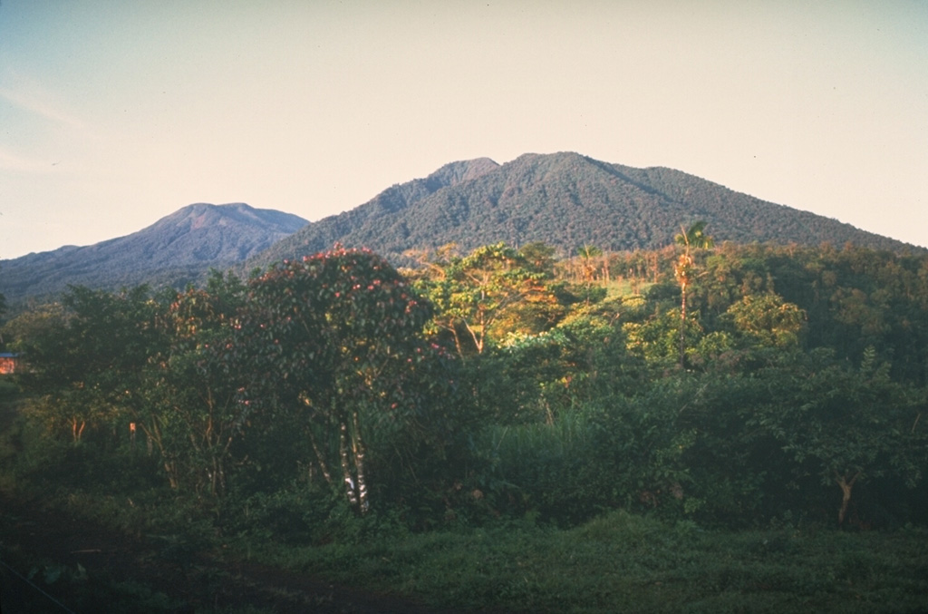
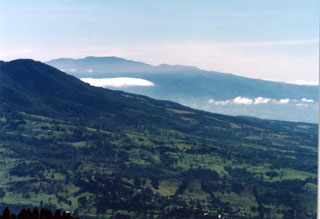
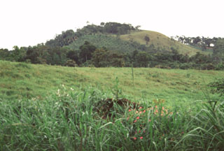
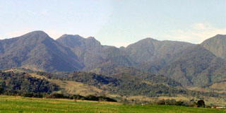
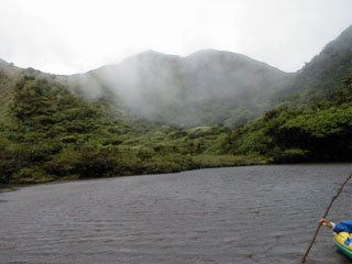
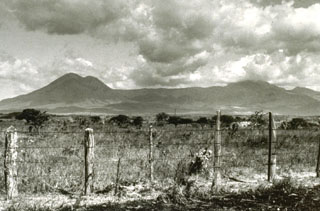 The Orosí volcanic complex is seen here from the north, with Orosí to the right and Volcán Cacao, the highest peak of the complex, to the left. Orosí is one of a cluster of four eroded and vegetated cones in the eastern part of Guanacaste National Park, NW Costa Rica.
Photo by William Melson (Smithsonian Institution).
 A lava flow descends on the west flank of Arenal volcano on from a degassing vent (Crater A) 6 September 1969. The flow overlies unvegetated terrain at the base of the volcano that was devastated by powerful explosions at the onset of an eruptive period beginning in July 1968. Continuous explosive activity accompanied by slow lava effusion continued from vents at the summit and upper western flank.
Photo by Dick Berg, 1969 (courtesy of William Melson, Smithsonian Institution).
 The Cervantes lava flows formed this uneven terrain on the south flank of Irazú. This massive flow deposit originated from two vents, Cerro Pasquí and another to the NW, producing the eastern and western Cervantes flows, respectively. The former traveled about 10 km to the base of the volcano. These flows are geochemically different, with the 0.17 km3 western flow being basaltic in composition and the 0.9 km3 eastern flow basaltic andesite. Radiocarbon ages for the flows range between about 14,000 and 17,000 years ago.
Photo by Guillermo Alvarado, 1986 (Instituto Costarricense de Electricidad).
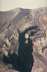
 This view from the east shows the active 600-m-wide crater that has been the site of most of Irazú's historical eruptions. The smaller, shallow crater to the lower left is the Diego de la Haya crater.
 Photo by William Melson, 1986 (Smithsonian Institution).
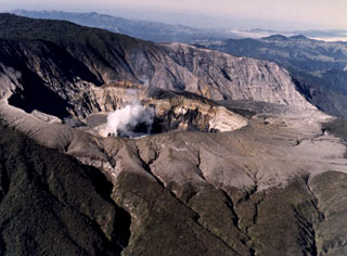
 The Irazú main crater is about 700 m wide and 200 m deep. It is seen here in 1998 from the summit, with ash-covered Playa Hermosa (a largely buried older crater) to the lower right, and the edge of Diego de la Haya crater to the upper right.
 Photo by Lee Siebert, 1998 (Smithsonian Institution).
 The Turrialba summit crater complex is seen here from the north, with the Central Valley of Costa Rica in the background. Three well-defined craters can be seen at the upper SW end of the broad summit area. Hydrothermally altered deposits can be seen at the central and SW summit craters (right), where geothermal activity continues.
 Photo by Federico Chavarria Kopper, 1999.
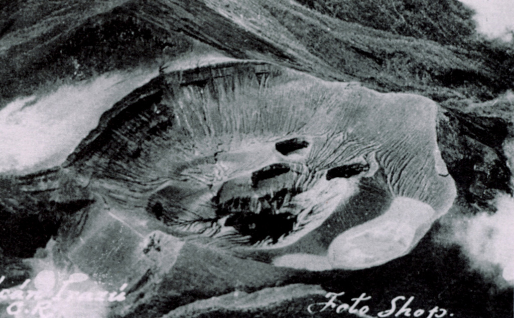
 Von Frantzius cone rises beyond the degassing active crater of Poás. This cone was constructed near the northern margin of the inner caldera.
Photo by Guillermo Alvarado (Instituto Costarricense de Electricidad).
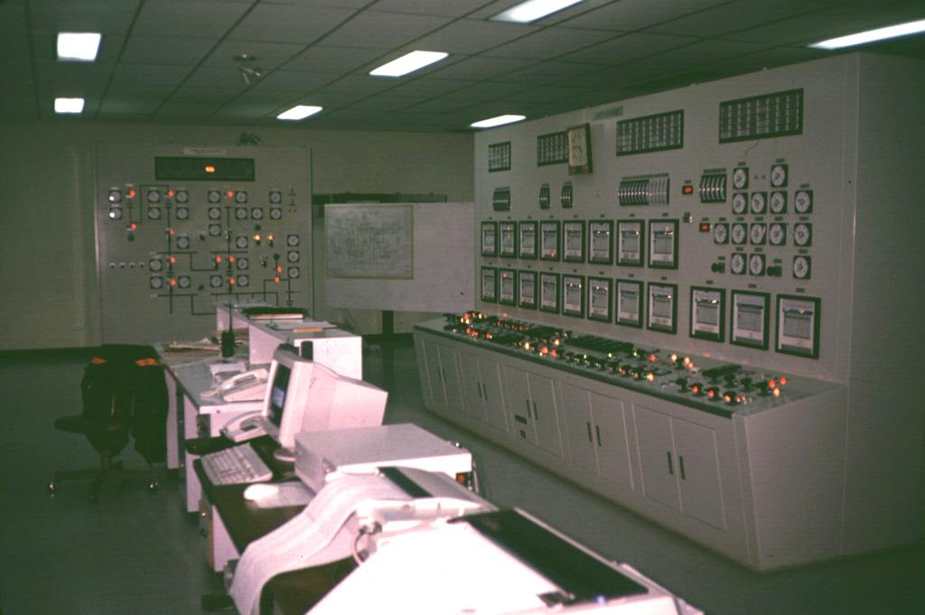
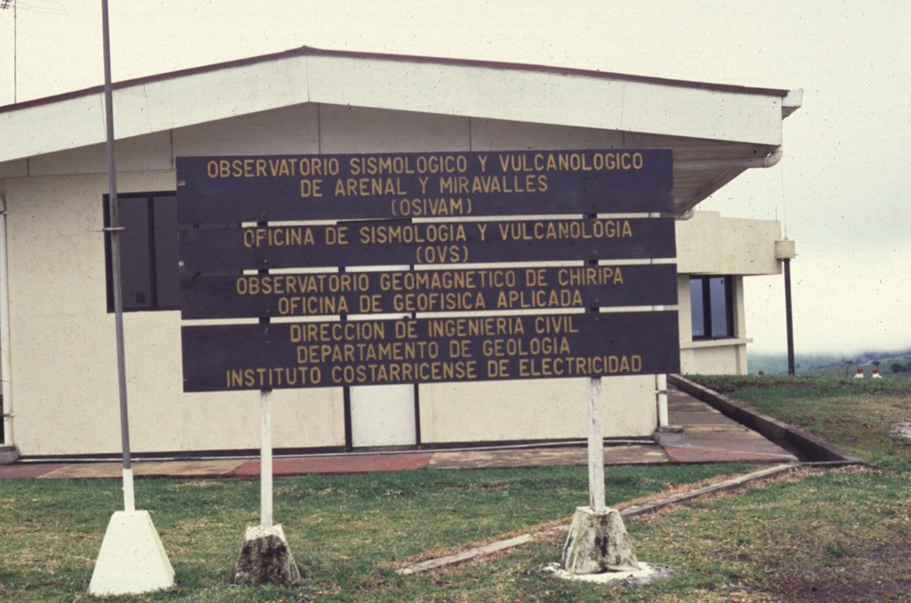
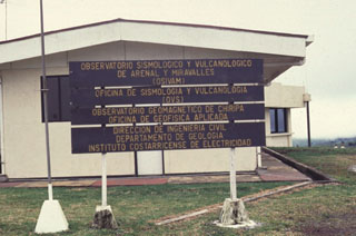 This is the OSIVAM observatory that monitors seismic and volcanic activity at Arenal and Miravalles volcanoes. The observatory is located in Quebrada Grande, 14 km from the town of Tilarán and west of Lake Arenal.
Photo by Guillermo Alvarado (Instituto Costarricense de Electricidad).
 Steam rises from of a small, hot lahar as it travels down the Río Tabacón on the NW flank of Arenal in August 1968, following a powerful explosive eruption that began on 29 July. The lahar damaged the road across the base of the volcano, about 4 km from the summit.
 Photo by William Melson, 1968 (Smithsonian Institution).
 The southern flank of Barva is in the foreground of this photo, with Irazú massif to the SE in the background. One of the youngest lava flows on Barva, the Los Angeles flow, traveled down the south flank almost as far as the city of Heredia. Barva and Irazú are visible from the nation's capital city, San José out of view to the right. Irazú is sometimes known as the "Colossus" due to its size and occasionally destructive eruptions.
 Photo by Ichio Moriya (Kanazawa University).
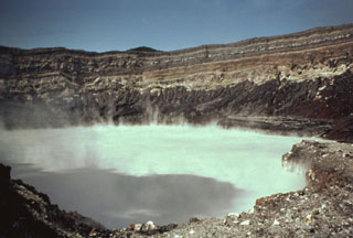
 The 700-m-wide Cráter Activo contains an acidic lake that is periodically partially ejected by explosive eruptions and therefore varies in depth. Trade winds from the ENE distribute acidic gas plumes to the SW, preventing vegetation growth.
 Photo by Guillermo Alvarado (Instituto Costarricense de Electricidad).
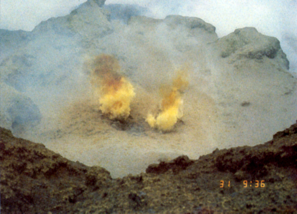
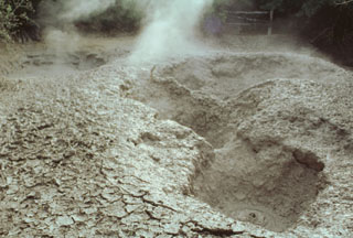
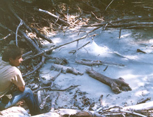
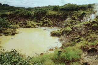
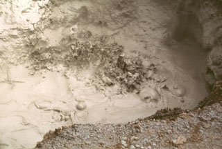 The Aguas Termales geothermal field on the lower southern flank of Rincón de la Vieja volcano contains mud pools like this one. Several geothermal areas occur along a NW trend at the base of the volcano. Soil mercury studies delineate a fault parallel to the volcanic front that connects the geothermal sites.
Photo by Lee Siebert, 1998 (Smithsonian Institution).
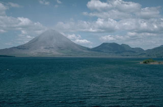 The Arenal volcanic complex, seen here in 1990 from Lake Arenal to its SW, consists of the Arenal edifice (left) and the older Cerro Chato (right), whose flat summit contains a crater and a crater lake. Activity at the complex has migrated to the NW from the Chatito and La Espina lava domes to the right of Cerro Chato.
 Photo by William Melson, 1990 (Smithsonian Institution)
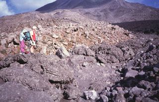
 Deposits of the Liberia Tuff are exposed in gullies SW of Rincon de la Vieja. The ignimbrite was emplaced about 1.6 million years ago and covered an area of 3,500-4,000 km2. Eruption of the 25 km3 ignimbrite was associated with formation of the 15-km-wide Guachipelín caldera, inside which the modern Rincón de la Vieja massif was constructed.
Photo by Lee Siebert, 1998 (Smithsonian Institution).
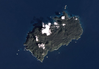 The 22 km2 Isla del Coco (Cocos Islands) is the subaerial portion of the Cocos Ridge, shown in this December 2019 Planet Labs satellite image monthly mosaic (N is at the top). A Pliocene-Pleistocene shield volcano partly forms the roughly 7-km-long (in the NE-SW direction) island. Steep cliffs around the coast expose thick columnar-jointed lava flows, thin lavas, and breccias (possibly debris flows).
Satellite image courtesy of Planet Labs Inc., 2019 (https://www.planet.com/).
 A vertical view into the crater lake of Poás volcano in December 1999 shows a gas plume (bottom center) originating from a vent in the south side of the lake. December plume heights ranged between 0.7 and 1 km. The 800-m-wide crater contains an acidic lake.
 Photo by Federico Chavarria Kopper, 2000.
 The 50-m-deep Turrialba central crater (seen here looking NE) and the SW crater were the source of a large eruption in 1866. Phreatomagmatic that year produced ashfall in Costa Rica's Central Valley for four days in January, and three days in February. Ash fell as far as Puntarenas and El Realejo in Nicaragua. Pyroclastic surges traveled more than 4 km, and small lahars traveled down the Río Aquiares and presumably other valleys.
Photo by José Enrique Valverde Sanabria, 1996 (courtesy of Eduardo Malavassi, OVSICORI-UNA).
 The Platanar volcanic complex on the horizon is the NW-most volcano in the Cordillera Central of Costa Rica. The complex consists of Platanar and Porvenir, which formed within the Chocosuela caldera. This view is from the east with the Hule maar, located about 11 km north of the Poás summit, in the foreground.
Photo by Mike Carr, 1983 (Rutgers University).
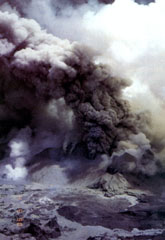
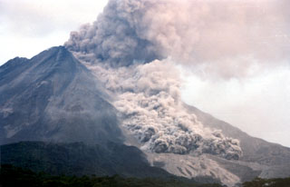 A pyroclastic flow travels down the NNW flank of Arenal on 5 May 1998, over light-colored deposits from earlier flows. As many as 23 pyroclastic flows took place during a 6-hour period that afternoon, descending the upper reaches of the Tabacón drainage basin. The pyroclastic flows reached estimated velocities of 60 km/hour.
 Photo by Olger Aragón, 1998.
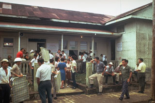 Officials bring supplies to residents evacuated as a result of the 1968 Arenal eruption. The village of Tabacón was nearly destroyed by ballistic ejecta produced by the powerful explosions at the onset of the eruption on 29 July. The town of Pueblo Nuevo was then established west of the area devastated by the explosions.
 Photo by Tom Simkin, 1968 (Smithsonian Institution).
 This June 1956 shows gas emissions from a new circular sub-crater formed in the summit crater of Poás volcano during an eruption from 1952-57. Phreatic explosions increased in intensity from 1952 to early 1953. Ash emission began in May 1953 and the crater lake was gone by 22 May. The first juvenile material was observed in mid-July, and Strombolian activity continued until 1955, after which geyser-like activity resumed. Lava appeared in the crater in 1957, and a phreatic explosion ejected ash on 25 December 1957.
 Photo courtesy of Jorge Barquero (Universidad Nacional Costa Rica), 1956.
 The Aguas Zarcas group of nine basaltic scoria cones is located on the northern flank of the Platanar-Porvenir complex. These cones lie 10-17 km behind the volcanic front of Costa Rica.
 Photo by Paul Kimberly, 1998 (Smithsonian Institution).
 People at the Arenal Volcano Observatory watch a S-flank pyroclastic flow on 23 January 1991. Pyroclastic flows occasionally descended the flanks throughout the long-lived eruption that began in 1968.
Photo by McDiarmid, 1991 (courtesy of William Melson, Smithsonian Institution).
 Ash and mud from a small phreatic explosion rise above the degassing Poás crater lake on 28 August 1988. Phreatic explosions had been occurring since June of the previous year and lasted for a few more months beyond August 1988. Activity was nearly continuous during the second half of August and the first week of September, with plumes containing mud rising 5-10 m. During the rest of the month plumes rose as much as 25 m. Small explosions continued, and by April 1989 the crater lake disappeared.
 Photo by E. Valverde, 1988 (published in Barquero, 1998)
 The Viejo-Porvenir complex is seen here rising above farmlands NE of the massif. The Viejo peak is on the left and Porvenir on the right.
Photo by Eliecer Duarte (OVSICORI-UNA).
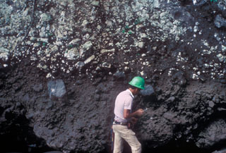
 A large 4 x 7 x 35 m block from a lava flow was transported about 900 m within a pyroclastic flow down the NE flank of Arenal on 5 September 2003. The flows were produced by lava flow fronts collapsing, descending to about 800 m elevation. Geologist Erick Fernandez from OVSICORI-UNA measures the dimensions of the block.
 Photo by Eliecer Duarte, 2003 (OVSICORI-UNA).
 Geologists stand on the margin of a pyroclastic flow deposit from an eruption of Arenal in 1993. In addition to the devastating pyroclastic flows accompanying the start of the eruption in July 1968, more frequent pyroclastic flows occurred in 1975, 1987, 1993, and 1998.
Photo by Guillermo Alvarado, 1993 (Instituto Costarricense de Electricidad).
 The foreground crater in this aerial photo from the SW is the principal summit crater of 3432-m-high Irazú volcano. The massive stratovolcano in the background is 3340-m-high Turrialba volcano. Roads of widely divergent quality lead to the summit craters of both these historically active volcanoes, the two highest in Costa Rica.
Copyrighted photo by Katia and Maurice Krafft, 1983.
 This February 1982 photo of the Poás active crater shows a gas plume rising from fumaroles on the southern crater rim. The northern crater wall in the background exposes pyroclastic deposits from phreatomagmatic and phreatic eruptions.
 Photo by National Aeronautical and Space Administration (NASA), 1982.
 This view of Irazú from the SE shows the road leading to the summit (upper left) and principal crater (right center). The road winds 32 km up the flanks to the summit crater complex, a tourist attraction near the capital city of San José. The roughly 200-m-deep summit crater has been the source of most historical eruptions.
Photo by William Melson, 1986 (Smithsonian Institution).
 An increase in Strombolian eruptions at Arenal had begun in March 1990. An ash plume rises above the summit on 4 April 1990, seen here from the volcano observatory 2.5 km S. This was part of a long-lived eruption that began in 1968. Explosions produced ash plumes to heights of 1 km above the summit and were accompanied by a lava flow that descended the Río Tabacón on the NW flank down to 700 m altitude. Small pyroclastic flows were also produced.
 Photo by William Melson, 1990 (Smithsonian Institution)
 Emissions rise from mud pools at the Aguas Termales thermal area, one of several at the lower southern flank of the Rincón de la Vieja massif in the national park of the same name.
Photo by Paul Kimberly, 1998 (Smithsonian Institution).
 Geologists stand in front of a steep lava flow margin in the Río Tabacón. Lava emission began on 19 September 1968, and in October the flow was advancing at rates of 10-30 m/day. By the time of this photo in November 1968 it had reached about 2.5 km from its source on the western flank. This area has now been buried by younger flows.
Photo by William Melson, 1968 (Smithsonian Institution).
 Wispy clouds cling to the walls of Tenorio's crater lake. This densely forested volcano provides habitat for some of Costa Rica's most exotic wildlife, including pumas, jaguars, tapirs, and a wide variety of bird life. Heavy rainfall in this forested terrain feeds crystalline waters that are important in regional hydrology.
Photo by Eliecer Duarte (OVSICORI-UNA).
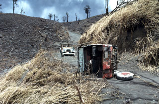 The jeep in the foreground was overturned by pyroclastic flows on 31 July 1968, during a major explosive eruption of Arenal. The 8-10 people who died on this date were within the devastated zone in the background to recover the bodies of people killed by the powerful 29 July eruptions.
 Photo by William Melson, 1968 (Smithsonian Institution).
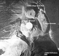 The Irazú summit crater complex is seen in this aerial view with north to the left. The Diego de la Haya crater is at the top and then to the main crater (Cráter Principal) contains a small lake. Playa Hermosa is a largely buried older crater. The road at the right leads to communication towers at the summit (lower right).
Aerofoto S. A., 1994 (published in Barquero, 1998).
 A plume containing ash and mud erupts through the Poás crater lake in July 1977 when phreatic explosions were produced at 25-minute intervals. This activity had begun in May 1977.
 Photo by S. Racchini, 1977 (Universidad Nacional Costa Rica, courtesy of Jorge Barquero).
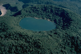 Densely forested Botos cone, the southernmost of the three volcanic cones forming the summit of Poás volcano, last erupted about 7500 years ago. Following this eruption activity shifted north to the presently active crater, whose unvegetated rim is seen at the upper left. The floor of the 1-km-wide Botos maar is now covered by the waters of Laguna del Agua Fria ("Cold Water Lake").
Copyrighted photo by Katia and Maurice Krafft, 1983.
 The broad Poás volcanic complex is seen here from the NE and shows and the northern flank of Cerro Congo in the center, with the von Frantzius cone to the left. An eruption of Cerro Congo around 5,140 years ago emplaced a pyroclastic flow deposit.
Photo by Mike Carr, 1983 (Rutgers University).
 Frequent eruptions have kept the Irazú summit craters devoid of vegetation. The thick dark-gray ash and scoria units that form the crater walls were emplaced during the 1963-65 eruptions.
Photo by Mike Carr, 1982 (Rutgers University).
 La Casa thermal spring is located in El Roble thermal area on the NE flank of the Tenorio volcanic complex. At the nearby Los Quemados thermal area 1 km to the south, vegetation has been destroyed over an area of 2,500 m2, and geothermal activity has killed small animals.
 Photo by Jorge Barquero, 1998 (OVSICORI-UNA).
 Arenal volcano, seen in this 1983 aerial view from the SE, is a conical stratovolcano that began a long-term eruption in 1968. Densely forested Cerro Chato (lower right) is an older volcano of the Arenal complex. Like Arenal, it is armored with lava flows. The latest eruption of Cerro Chato consisted of phreatomagmatic explosions that formed its summit crater, which is now filled by a lake. At the extreme lower right is Chatito, a lava dome of the Cerro Chato group.
Copyrighted photo by Katia and Maurice Krafft, 1983.
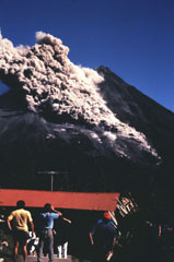
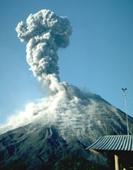
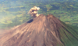 An ash plume rises from the active summit crater of Arenal in this April 1998 view from the south. A small saddle separates the unvegetated post-1968 cone from the pre-1968 cone (right). During April 1998 lava flows traveling down the northern-to-western flanks, and blocks on the NW Crater C wall, broke loose and tiggered small avalanches. This relatively minor activity preceded a larger eruption that produced pyroclastic flows on 5 May.
 Photo by Federico Chavarria Kopper, 1998.
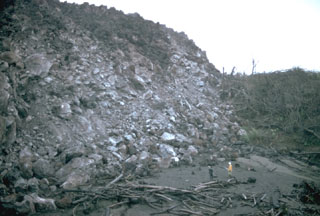
 This topography south of Miravalles volcano is typical of that resulting from large volcanic debris avalanches and represents material produced by major edifice collapse. Large boulders are abundant, such as those in the foreground.
 Photo by Lee Siebert, 1998 (Smithsonian Institution).
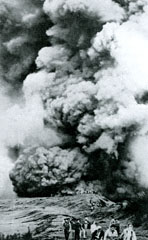
 An aerial view overlooks the impact crater field of the 29 July 1968 eruption on the W flank near Pueblo Nuevo. Most of the craters are partially filled by rainfall. These secondary craters, produced by the high-velocity impact of blocks ejected from a new crater that opened on the W flank of Arenal, ranged in size from a few m to 30 m in diameter. The crater field extended as far as about 5 km from the vent. The devastating eruption of 29 July killed about 80 people.
Photo courtesy of Tom Simkin, 1968 (Smithsonian Institution).
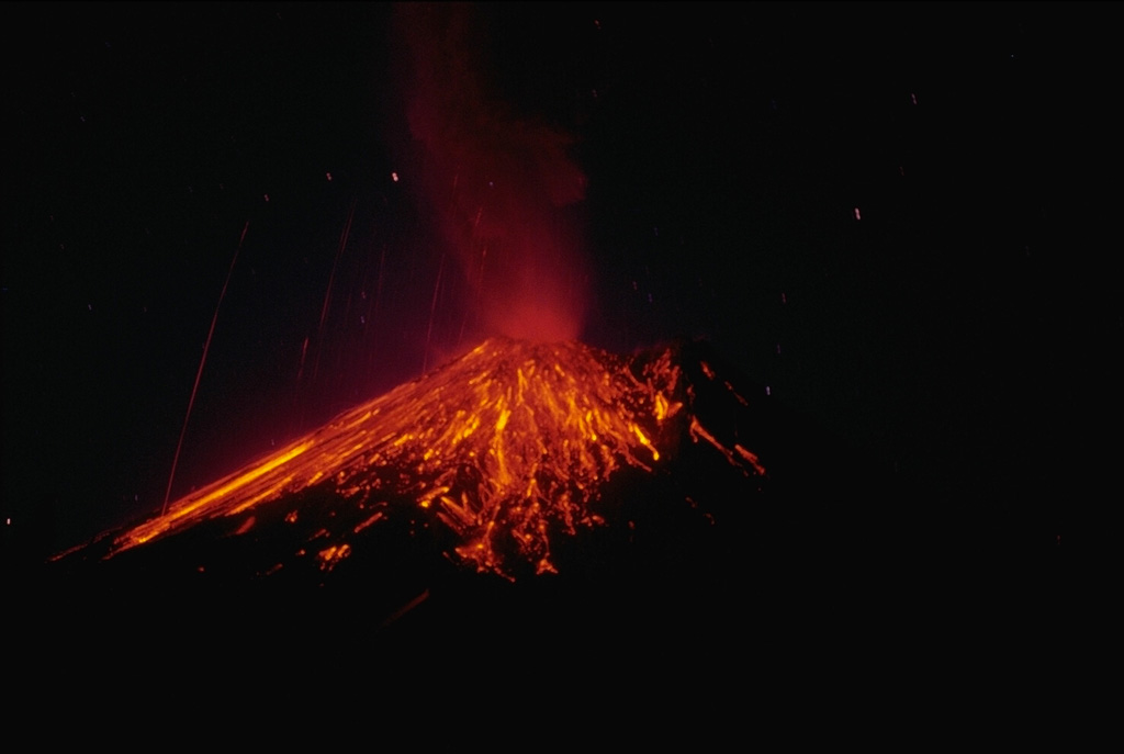
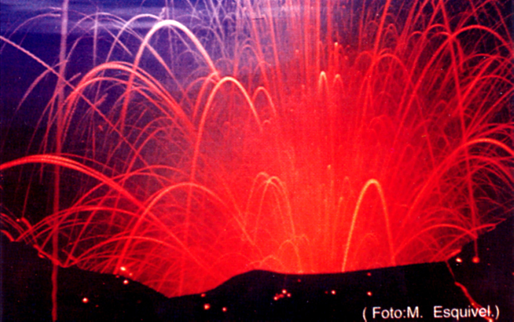
 A nighttime time-exposure photo of Arenal on 3 April 1990 shows the paths of incandescent blocks that landed on the upper flanks and traveled downhill. Near-constant lava effusion, accompanied by periods of heightened explosive activity, has occurred since a large explosive eruption in 1968.
Photo by William Melson, 1990 (Smithsonian Institution).
 The Poás crater lake is seen here on 4 October 1987 during an intermittent eruption lasting from June 1987 to June 1990. Sporadic small phreatic explosions had started in June 1987 and continued until at least October 1988. The crater lake disappeared by April 1989, and in the following month ash plumes reached heights of 1.5-2 km above the crater.
 Photo by José Enrique Valverde Sanabria, 1987 (courtesy of Eduardo Malavassi, OVSICORA-UNA).
 This view shows a lava flow on the WNW flank of Arenal, which originated from Crater A on the lower west flank. At the time of this September 1969 photo the flow had been active for one year. The thick andesite flow initially traveled down the Río Tabacón valley to the NW, but multiple lobes eventually filled different drainages.
Photo by William Melson, 1969 (Smithsonian Institution).
 Gas emissions rise from vents in the Aguas Termales thermal area on the southern flank of Rincón de la Vieja volcano. A popular trail in Rincón de la Vieja National Park goes around the mud pools and fumaroles of the geothermal area.
Photo by Paul Kimberly, 1988 (Smithsonian Institution).
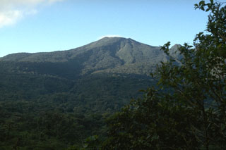
 The verdant forests mantling the Tenorio volcanic complex are seen from the Río Celeste drainage. The Tenorio complex consists of five volcanic cones aligned NNW-SSE. Several archaeological sites are located around the complex, testament to the importance of the area to prehispanic Indians. The Tenorio complex marks the SE end of the Guanacaste Range; a range of low hills separates it from the next volcano to the SE, Arenal.
Photo by William Melson, 1985 (Smithsonian Institution).
 Volcán Barva has a broad summit containing three main peaks (top right) as seen here looking N from the Central Valley of Costa Rica. A large 2 x 3 km crater opens to the ESE behind the summit. A large Plinian eruption occurred at Barva during the early Holocene.
Photo by William Melson, 1993 (Smithsonian Institution)
 This 1968 view of the vegetated summit crater of Arenal is the only known photo of the summit prior to the major eruption that began that year. The previous significant eruption of Arenal (even larger than in 1968) took place in about 1440 CE, and also produced powerful explosions with pyroclastic flows and lava flows.
Photo by Y. Monestel, 1968 (courtesy of Jorge Barquero, OVSICORI-UNA).
 The low-angle, grass-covered eastern slopes of Cerro Tilarán (also known as Cerro Tovar) are seen from the SW part of the town of Tilirán. The small 634-m-high andesitic shield volcano lies at the NW end of the Tilarán Range west of Lake Arenal. The Tilarán shield is overlain only by tephra deposits from Arenal (maximum age about 7000 years), but has an Argon-Argon date of 1 million years.
Photo by Eliecer Duarte (OVSICORI-UNA).
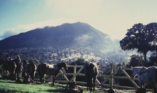 Massive Turrialba volcano, seen here from the west, lies 24 km NW of the city of the same name. The stratovolcano covers an area of about 500 km2. The flanks of the volcano display youthful-looking lava flows, and historical eruptions have taken place from summit craters. Guayabo National Monument, an important archaeological park, lies at the southern base of the volcano and marks the site of human occupation that dates back to 500 BCE.
 Photo by Guillermo Alvarado, (Instituto Costarricense de Electricidad).
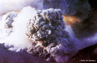 Ashfall from the 1963-65 eruption of Irazú affected both populated areas and agricultural lands. In the weeks following the beginning of the eruption on 13 March 1963 ashfall at times restricted visibility to 30 m in the capital city of San José, paralyzing traffic. Ashfall caused extensive damage to farmlands, resulting in the death of livestock. Remobilization of ash during the rainy season caused lahars that destroyed houses, roads, and bridges, and caused fatalities.
 Photo by W. Schaer (published in Barquero, 1998).
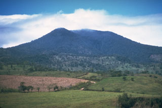 The forested Tenorio volcanic complex contains a group of volcanic cones at the SE end of the Guanacaste Range. Geothermal activity is present on the NE flank.
Photo by Cindy Stine, 1989 (U.S. Geological Survey).
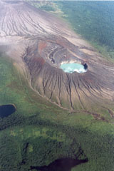 This photo from the E overlooks the Rincón de la Vieja summit cone complex in the Rincón de la Vieja National Park. The turquoise-colored lake is within the Cráter Activo and the darker Laguna Fria is to the lower left. The arcuate, forested ridge to the lower left is the rim of Rincón de la Vieja cone itself. Erosional gullies have formed within tephra deposits across the Cráter Activo and the Von Seebach cone (upper left) flanks.
Photo by Federico Chavarria Kopper, 1995 (courtesy of Eduardo Malavassi, OVSICORI-UNA).
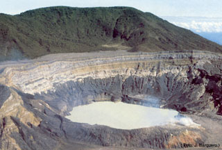 The acidic crater lake at the summit of Poás is seen here from the overlook on the southern crater rim. The von Frantzius cone in the background formed along the northern rim of the innermost of two large nested calderas at the summit. The crater lake has been the source of frequent phreatic eruptions.
Photo by Jorge Barquero, 1985 (Universidad Nacional Costa Rica).
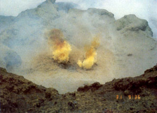 Fumarole gases at Poás are sometimes tinted yellow by the sulfur content. Sulfur clasts have been ejected during some explosive eruptions. Acidic gas plumes have damaged vegetation in the national park and surrounding areas, causing widespread devastation to coffee and other crops. An explosion on 9 April 1988 dropped acidic sulfur-rich mud on visitors, cars, and plants near the tourist overlook.
Photo by Jorge Barquero (Universidad Nacional Costa Rica).
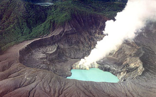 A gas plume rises from the lava dome on the south side of the Poás summit crater lake in this February 2000 view from the NW. Degassing produced plumes up to about 700 m high in May and bubbling within the crater lake had been reported since late March. Temperatures of around 40°C were measured on the NE shore of the lake at various points in May. The 400-m-wide Laguna del Fría is visible at the upper left within the Botos crater.
Photo by Federico Chavarria Kopper, 2000.
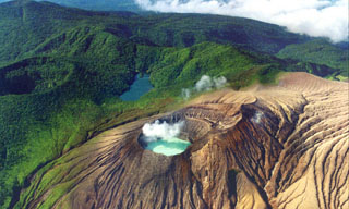 This aerial photo from the north overlooks the Rincón de la Vieja summit cone complex in NW Costa Rica. A gas plume rises from the acidic Cráter Activo lake, and erosional gullies have formed across the flanks. The darker Laguna Fria beyond the Cráter Activo is a non-volcanic lake formed between the vegetated Rincón de la Vieja crater (far-left) and the ridge extending to Santa María to the upper left of the photo.
 Photo by Federico Chavarria Kopper, 1996.
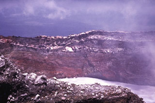 The walls of Cráter Activo expose thick sequences of oxidized and hydrothermally altered pyroclastic deposits and lighter lava flows. Many eruptions from Active Crater have originated from vents beneath the acidic crater lake.
Photo by Guillermo Alvarado (Instituto Costarricense de Electricidad).
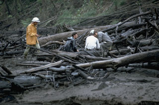 Geologists investigate trees within in a pyroclastic flow deposit along the Río Tabacón on the NW flank of Arenal in November 1968. The trees are aligned parallel to the rapid pyroclastic flow direction. Devastating pyroclastic flows traveled down existing drainages during 29-31 July 1968. One of the largest, with an estimated volume of 0.0018 km3, entered the Río Tabacón. The deposits ranged to more than 30 m thick, but were typically about 10 m. Fumaroles on their surface were active for more than two years.
Photo by William Melson, 1968 (Smithsonian Institution).
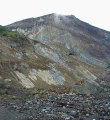 Hydrothermally altered rocks and lava flows are exposed in cliffs on the Irazú upper northern flank. Las Fumaroles (near top center), a thermal area below the cliffs, was the source of an explosive eruption in December 1994 that also produced an avalanche and lahar down the Río Sucio.
Photo by Eliecer Duarte, 2001 (OVSICORI-UNA).
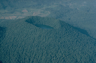 The last eruptions of Cerro Chato volcano, at the SE end of the Arenal volcanic complex, took place about 3500 years ago. Phreatomagmatic explosions produced a crater at the summit of the volcano that is now filled by a lake. This 1983 aerial view from the east shows the densely forested summit of Cerro Chato, with the higher western rim rising above the crater lake.
Copyrighted photo by Katia and Maurice Krafft, 1983.
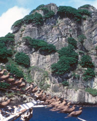 Outcrops of trachyte form cliffs on the northern side of Isla Coco. Seabirds perch on lines of the R/V Searcher of the University of Costa Rica. A massive trachytic lava dome lies between Bahia Wafer and Bahia Chathan on the NE side of the island.
 Photo by Pat Castillo, 1984 (Scripps Institution of Oceanography, University of California San Diego).
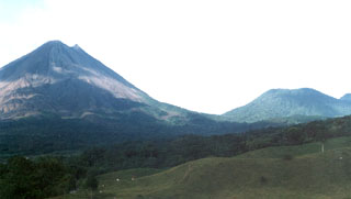 Arenal (left) and Cerro Chato (right) are seen from near El Castillo on the SW side of the volcanic complex. Activity has migrated NW since the earliest eruptions dating back to 38,000 years ago. La Espina and Chatito lava domes are out of view to the right.
 Photo by Jorge Barquero (OVSICORI-UNA).
 There is a group of scoria cones on the southern flank of Irazú near the road to the summit. Flank cones were the source of voluminous lava flows such as the roughly 1.2 km3 Cervantes flow, which traveled about 10 km down the SSE flank to the Río Reventazon at the base of the volcano.
Photo by Ichio Moriya (Kanazawa University).
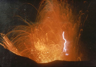 This photo captures volcanic lightning within incandescent ejecta from the Irazú summit crater in 1963. Intermittent ejection of ash, lapilli, blocks, and bombs took place for two years beginning from March 1963. Late in 1963 an ash plume reached 8 km above the vent in four minutes.
 Photo by M. Esquivel, 1963 (published in Barquero, 1998).
 Lava flows from the Arenal eruption that began in 1968 form the surface of the SW flank in this view from the Arenal Volcano Observatory. The active crater (Crater C) is at the summit, while the peak to the right (containing Crater D) is the previous summit.
Photo by Jorge Barquero, 1998 (OVSICORI-UNA).
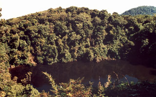 The SW peak of Barva has at least four volcanic cones. This cone contains the 70-m-wide Barva crater lake. Nineteenth-century visitors to the lagoon noted similar dense vegetation as seen today, discounting reports of earlier historical eruptions.
Photo by José Enrique Valverde Sanabria, 1999 (courtesy of Eduardo Malavassi, OVSICORI-UNA).
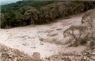 The main pyroclastic flow deposit of 5 May 1998 fills the channel of the Río Tabacón on the NW flank of Arenal. Nearly two dozen pyroclastic flows took place that afternoon. Transported blocks were semi-rounded and had abundant cooling joints; they often contained breadcrust textures from expansion of the partially molten core. Their sizes ranged up to 4 m in diameter. At an undisclosed time of inspection the block's temperatures were as high as 525°C, whereas at 10 cm depth the smaller tephra of the deposit's matrix reached only 100°C.
Photo by Erick Fernandez, 1998 (OVSICORI-UNA).
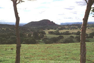 The small pyroclastic cone Cerro Chopo (also known by the religious names of Anunciación, Coronación, or Asunción) is seen here from the ENE along the road between Canas and Tilarán south of the Guanacaste Range. The 250-m-high basaltic pyroclastic cone was constructed over the flat-lying surface in the foreground, which is underlain by Pleistocene regional ignimbrites, lahars, and andesitic lava flows. The age of the cone has been roughly estimated to be between 40,000 and 10,000 years old.
 Photo by Lee Siebert, 1998 (Smithsonian Institution).
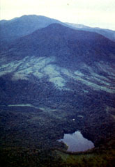 This view from the north looks across vents extending north from Poás. In the foreground is the Hule maar complex, with Laguna Bosque Alegre to the left and Laguna Congo at bottom right; the forested peak in the middle distance is Cerro Congo. Poás volcano is about 12 km to the south and forms the horizon here.
Photo by Guillermo Alvarado, 1987 (Instituto Costarricense de Electricidad).
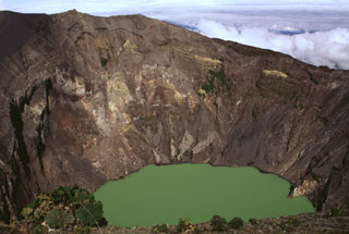 The Irazú summit crater is about 700 m wide and nearly 200 m deep and has been the source of most of Irazú's historical eruptions. Geothermal activity is frequently observed around of the lake, and the water color varies with changing atmospheric conditions.
Photo by Lee Siebert, 1998 (Smithsonian Institution).
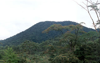 The western flanks of Cerro Chato on the SE side of Arenal are seen here from the OVSICORI-UNA/Smithsonian Institution volcano observatory at Arenal in 1998. At this time, the last known eruption was about 3,500 years ago. Following that eruption, it contained a 500-m-wide summit crater that is partially filled by Laguna Cerro Chato.
 Photo by Jorge Barquero, 1998 (OVSICORI-UNA).
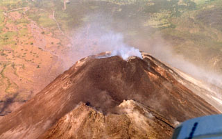 An aerial perspective of the Arenal summit area shows the older cone in the foreground and the active degassing cone in the background. Notice the newly formed small darker-colored cone on the right (north) in this 10 March 1999 photograph.
 Photo by Federico Chavarria Kopper, 1999 (courtesy of Eduardo Malavassi, OVSICORI-UNA).
 An aerial view shows the summit crater of Irazú volcano prior to the 1963 eruption, with the Diego de la Haya crater at the lower left and Playa Hermosa at the left-center. The floor of the main crater (Cráter Principal) contains several small explosion craters. The ridge on the right side of the crater floor is the remnant of the pyroclastic cone formed during the 1723 eruption. Repeated explosive eruptions during 1963-65 greatly modified the summit crater, and the individual vents seen here were merged into a single large crater.
Anonymous photo (published in Alvarado, 1989).
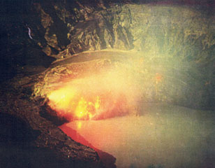 Moderate eruptions with strong gas and ash emission took place from the Poás main crater during March to May 1981. This 19 March time-exposure photograph from the northern crater rim shows an incandescent lava dome.
 Photo by Eduardo Malavassi, 1981 (OVSICORA-UNA)
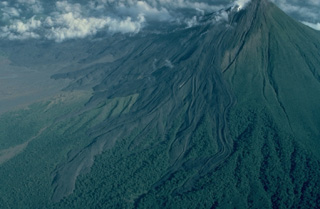 Lava flows armor the western flank of Arenal volcano in Costa Rica. All the flows seen here were emplaced during a long-term eruption that began in 1968. This 1983 aerial view from the SSW shows many individual lava-flow lobes. Prominent flow levees are visible, particularly on the flows at the right. Lava flows from the current Arenal eruption extend 4 km to the NW and about 2.5 km to the SW.
Copyrighted photo by Katia and Maurice Krafft, 1983.
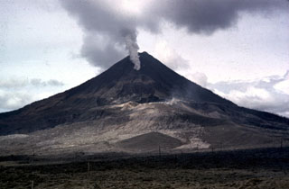 The initial explosions of the 1968 Arenal eruption took place at three craters located from the summit down the west flank. Crater A is visible in the sunlight at the center of the photo; this was the source of the devastating explosions on 29 July. A gas plume rises from Crater B, obscuring Crater C behind it. Lava effusion from Crater C began in September and continued for many years.
 Photo by William Melson, 1968 (Smithsonian Institution).
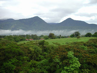 Volcán Platanar rises above farmlands to the north. The summit is also known as Cerro Congo after the howler monkeys occupying its slopes. It lies about 8 km SE of the city of Quesada at the northern end of the Palmira-Chocosuela-Platanar volcanic complex.
 Photo by Eliecer Duarte (OVSICORI-UNA).
 Electrical power from the Miravalles geothermal plant is distributed from the control room of Project CORTEZ. The Miravalles I and II wells produce 60 and 55 MW of power, respectively, through reinjection. The vapor-phase Miravalles III well is expected to produce 27.5 MW. The depths of the geothermal wells vary from 959 to 3022 m.
Photo by Guillermo Alvarado (Instituto Costarricense de Electricidad).
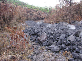 This is a pyroclastic flow deposit that was emplaced down the NE flank of Arenal on 5 September 2003, singeing vegetation on either side of the narrow valley. A series of pyroclastic flows were produced over two hours starting at 1055. The pyroclastic flows originated from the collapse of lava flows on the steep upper flank. Accompanying ashfall occurred to the W and NW.
Photo by Eliecer Duarte, 2003 (OVSICORI-UNA).
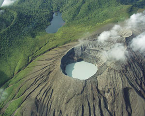 This view from the N looks into the acidic Cráter Activo lake with layered pyroclastic deposits exposed in the SW crater wall. The crater rim of the forested Rincón de la Vieja cone is to the upper left, with the non-volcanic Jilgueros lake at the top.
 Photo by Eliecer Duarte (OVSICORI-UNA).
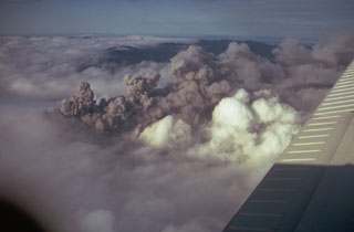 A dark ash plume at Arenal rises above white atmospheric clouds in 1968. A major explosive eruption began on 29 July 1968 from three new craters down the western flank. A series of major explosions took place between the morning of 29 July and the afternoon of 31 July.
Photo by Tom Simkin, 1968 (Smithsonian Institution).
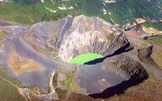 An aerial view from the SE looks down on the Irazú summit crater complex in 1999. Three craters are visible here, the 700-m-wide main crater with a green lake, the Diego de la Haya crater (lower right), and the older Playa Hermosa crater (lower left).
 Photo by Federico Chavarria Kopper, 1999.
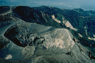 Irazú, Costa Rica's highest volcano, rises to 3432 m east of the capital city of San José. The volcano is vegetated to within a few hundred meters of its broad summit crater complex. At least 10 satellitic cones are located on the south flank of Irazú. The focus of eruptions at the summit crater complex has migrated to the west towards the historically active crater, which contains a small lake. Ashfall from its last major eruption during 1963-65 caused significant disruption to San José and surrounding areas.
 Copyrighted photo by Katia and Maurice Krafft, 1983.
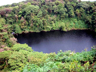 The roughly 300-m-wide Barva crater lake is surrounded by dense forest. The clear waters of the shallow lake are about 8 m deep, and a pH of 4-5 was measured in December 2002.
 Photo by Raul Mora, 2002 (University of Costa Rica).
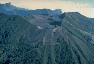 The summit crater complex of Turrialba, Costa Rica's 2nd-highest volcano, is seen here from the SW. Three overlapping summit craters are located at the apex of a large 2 x 4 km summit depression that is widely breached to the NE. The massive stratovolcano had four explosive eruptions during the past 2000 years. These produced pyroclastic flows and surges that devastated areas currently used for agricultural purposes. The most recent eruptions of Turrialba took place during the 19th century.
Copyrighted photo by Katia and Maurice Krafft, 1983.
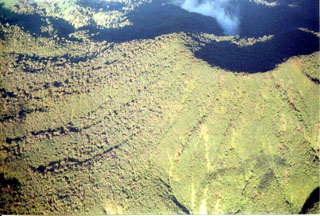 The Platanar summit crater is to the upper right of this photo taken from the south. Holocene lava flows are on the western flank.
Photo by Federico Chavarria Kopper, 2004.
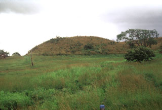 This hummock is part of a massive debris avalanche deposit that formed by collapse of Volcán Cacao. The avalanche traveled across the flat-lying Pacific coastal plain as far as the Central American highway, near where this photo was taken.
Photo by Lee Siebert, 1998 (Smithsonian Institution).
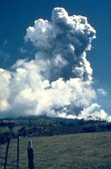 The first of several major eruptions of Irazú between 1963 and 1965 took place on 13 March 1963. These eruptions produced heavy ashfall over much of central Costa Rica, severely affecting agricultural areas and causing major economic problems. Lahars caused fatalities and destroyed hundreds of houses.
Photo by Dick Stoiber, 1963 (Dartmouth College).
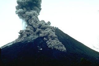 Pyroclastic flows descend the flanks of Arenal on 7 July 1987. This was part of the long eruption that began in 1968. The largest pyroclastic flow in this photo taken from the volcano observatory (2.5 km SSW of the summit) is traveling down the SSE flank.
Photo by William Melson, 1987 (Smithsonian Institution)
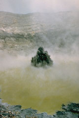 Phreatic eruptions resumed from Poás in June 1987, ejecting lake water and sediments to a maximum reported height of 75 m. This 23 January 1988 photo shows the typical ejection of plumes of gas, ash, and mud above the crater lake. The crater lake disappeared by 19 April 1989 then ash emission began. Phreatic activity began again after rainwater formed a new lake. During May 1989 ash plumes reached heights of 1.5-2 km above the crater.
Photo by Gerardo Soto, 1988 (Instituto Costarricense de Electridad).
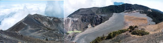 A panoramic view from the summit of Irazú volcano shows the E-W-trending summit crater complex. The main crater is partially filled by a lake in the center of the photo, the floor of the broad flat-bottomed Playa Hermosa crater at the right is covered by deposits of historical eruptions, and the Diego de la Haya crater lies in the right background.
Photo by Ichio Moriya (Kanazawa University).
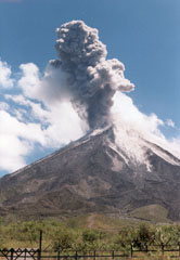 An ash plume rises above Arenal on 2 June 1998, seen here from the west flank. Routine intermittent explosive activity had resumed at this time following major pyroclastic flows on 5 May. Lava flows from the long-lived eruption that began in 1968 can be seen on the volcano's flanks.
 Photo by Jorge Barquero, 1998 (OVSICORI-UNA).
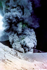 Intermittent explosive activity during the 1963-65 Irazú eruption cumulatively produced extensive ashfall that caused significant economic damage to San Jose and other populated areas of the Central Valley of Costa Rica. During the first weeks of January 1964 heavy ashfall was deposited as far away as Tamarindo beach on the Pacific coast and Lake Nicaragua, 180 km NE of the volcano.
Photo by W. Schaer (published in Barquero, 1998).
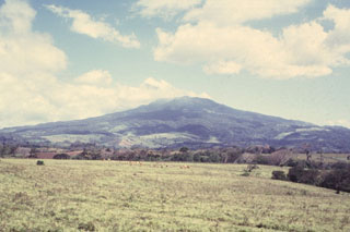 Rincón de la Vieja is seen here across the coastal plain from the west. The volcanic massif is the largest in NW Costa Rica with an estimated volume of 130 km3. The Liberia Tuff originated from here during the early Pleistocene and covered an area of 3,500-4,000 km2.
Photo by Guillermo Alvarado (Instituto Costarricense de Electricidad).
 Radial drainages draped with lush vegetation descend the flanks of Poás volcano. These waterfalls on the Río La Paz lie on the eastern flank of Poás along the road between the central valley and the Atlantic coastal plain. NE-flank drainages empty into the Río Sarapiquí and then the Río San Juan en route to the Carribean Sea. Poás is the centerpiece of a national park that preserves highland forests and abundant wildlife.
 Photo by Paul Kimberly, 1998 (Smithsonian Institution).
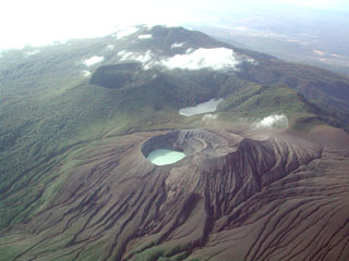 The flanks surrounding the Rincón de la Vieja Cráter Activo are shown in this aerial view from the NE. Los Jilgueros lake is in the middle and the large forested inactive crater behind it and to the left.
 Photo by Eliecer Duarte (OVSICORI-UNA).
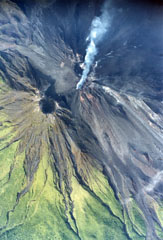 This 8 September 1999 aerial photo shows an active lava flow from the Crater C complex directed towards the NNW, with lobes to the NE. The peak below and to the left of the degassing crater is the pre-1968 summit crater. The 1968-2010 eruption produced lava flows that covered much of the NW-to-SW flanks.
Photo by Federico Chavarria Kopper, 1999 (courtesy of Eduardo Malavassi, OVSICORI-UNA).
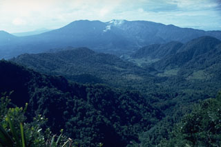 Poás volcano is visible in this view from the NW with small gas plumes rising from the Botos cone in the center of the complex; the peak to its left is von Frantzius cone. The flank of Cerro Congo is across a saddle from von Frantzius on the far-left horizon. Two large calderas are at the summit, the youngest of which formed about 40,000 years ago.
Photo by Dick Berg, 1969 (courtesy of William Melson, Smithsonian Institution).
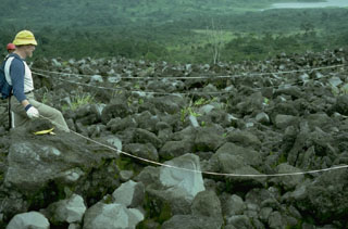 A long-term project by botanists from the Smithsonian Institution studied plant succession on lava flows at Arenal volcano. This field site is located on the west flank. Lake Arenal is visible at the upper right.
Photo by William Melson, 1988 (Smithsonian Institution).
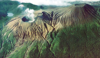 Part of the complex summit region of Rincón de la Vieja, the largest volcano in NW Costa Rica, is seen here from the north. Steam rises from the lake-filled Cráter Activo to the left, ENE of the Von Seebach cone (right). Laguna Fria (far-left) is not a crater lake, but a freshwater lake that formed between overlapping cones of the summit complex, which extends east and west beyond this area. Frequent eruptions from Cráter Activo have left surrounding terrain unvegetated.
Photo by Federico Chavarria Kopper, 1999.
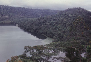 The Hule maar complex formed about 11 km N of the Poás summit. The 2-km-wide complex contains Laguna Hule on the W side, the small Laguna Bosque Alegre on the N, and Laguna Congo to the NW. The cone to the right rises about 130 m above the roughly 20-m-deep lake.
Photo by Guillermo Alvarado, 1987 (Instituto Costarricense de Electricidad).
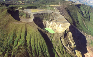 Several craters have formed at the summit of Irazú: the gray, flat floor of the Playa Hermosa crater, Irazú's main crater (center), and the Diego de la Haya crater (top left). A green lake fills the bottom of the main crater in this 1999 view, the source of most of Irazú's historical eruptions.
Photo by Federico Chavarria Kopper, 1999.
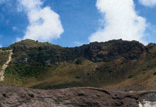 The rim of one of the three craters filling the large summit depression of Turrialba volcano is seen in the foreground. A scarp wall is visible in the background. Eruptions during the 18th and 19th centuries have originated from the three small craters.
Photo by Gerardo Soto (published in Alvarado, 1989).
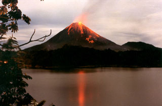 Strombolian eruptions from Arenal volcano are reflected in Lake Arenal in December 1992 during an eruption that began on 29 July 1968. The eruption produced major explosions and pyroclastic flows from three new vents on the west flank, destroying two towns and killing 78 people. The eruption continued through to 2010 and lava flows formed an extensive lava field on the west flank, accompanied by intermittent explosive activity.
Photo by Olger Aragón, 1992.
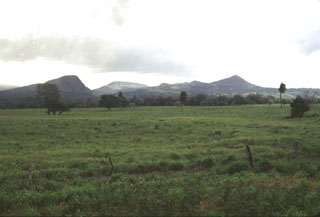 Cerro San Roque (left), Cerro Gongora (center), and Cerro Cañas Dulces (right) lava domes, seen here from the west along the Pan-American highway, are just outside the Guachipelín caldera. The domes formed prior to the eruption of the Liberia Tuff and formation of the caldera about 1.6 million years ago.
Photo by Lee Siebert, 1998 (Smithsonian Institution).
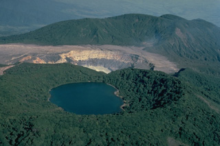 The summit of Poás volcano, seen here in 1983 from the south, contains a group of craters along a N-S line. The forested Botos cone (foreground) is filled with the waters of Laguna del Agua Fría (also known as Laguna del Poás). The unvegetated active summit crater appears at the center. A third crater cuts the south side of the forested von Frantzius cone in the background.
Copyrighted photo by Katia and Maurice Krafft, 1983.
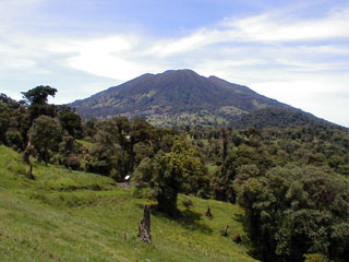 The summit of Turrialba, the easternmost volcano in the Cordillera Central, is seen here from the SW. It is about 25 km NW of the city of the same name. The summit area is designated as Turrialba National Park, and its northern flanks are part of the extensive Cordillera Volcánica Central forest reserve.
Photo by Eliecer Duarte (OVSICORI-UNA).
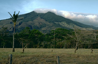 Miravalles, seen here looking NE from the Guayabo caldera floor, is the youngest feature of the volcanic complex. Multiple edifices have grown in the eastern part of the 15 x 20 km caldera, which formed sometime between 1.5 million and 600,000 years ago.
Photo by Guillermo Alvarado, 1985 (Instituto Coastarricense de Electricidad).
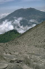 Turrialba is the SE-most Holocene volcano in Costa Rica, seen here from the upper flank of Irazú to its SW. There are three craters in the upper end of a broad summit scarp that opens towards the NE.
Photo by William Melson, 1969 (Smithsonian Institution)
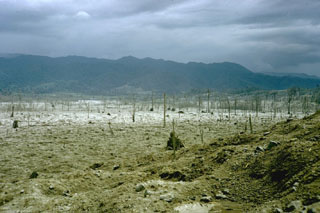 A series of powerful and deadly explosions on 29 July 1968 initiated a new eruptive period at Arenal volcano. This November 1968 photo shows the destruction to vegetation within a broad, devastated area on the western flank. Ballistic ejecta stripped trees of leaves to distances as far as 5 km west of the summit.
Photo by William Melson, 1968 (Smithsonian Institution)
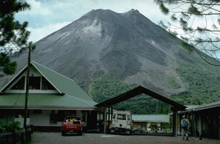 The Arenal Observatory Lodge was constructed at the site of a joint OVSICORI-UNA/Smithsonian Institution volcano observatory established on the SSW flank. The observatory building itself, out of view to the right, was used for seismic monitoring and visual documentation of the frequent eruptive activity from Arenal. This photo was taken in 1992.
Photo by William Melson, 1992 (Smithsonian Institution).
 This May 2001 photo shows a gas plume bring dispersed to the west from Crater C, the most recent active summit crater of Arenal. A small saddle separates Crater C from Crater D (left margin), the vent of a major explosive eruption that occurred around 1530 CE.
Photo by Federico Chavarria Kopper, 2001.
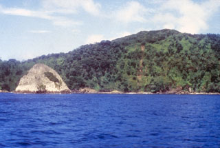 The light-colored pyramidal island at the left is a small island of trachytic rocks between Bahia Wafer and Bahia Chathan, on the NE side of Cocos Island. The plug-like islet lies north of a massive lava dome lying between the two bays and consisting of flow-banded benmoreitic, trachytic, and quartz trachytic rocks.
Photo by Pat Castillo, 1984 (Scripps Institution of Oceanography, University of California San Diego).
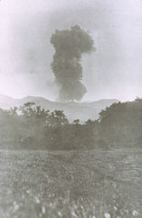 An ash plume rises above Rincón de la Vieja on 4 June 1922. No further eruptive activity was recorded until 1966, when eruptions began occurring more frequently.
 Photo by José Tristan, 1922 (courtesy of Jorge Barquero).
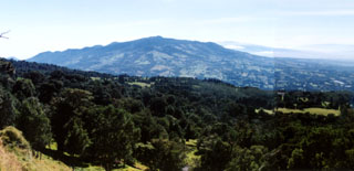 Barva volcano rises to the east above the southern flanks of neighboring Poás volcano. The massive Barva volcano is dotted with numerous satellitic vents, some of which are visible along the irregular northern horizon (left). Multiple lava flows descend the southern flank of Barva. One of the more recent of these is the Los Angeles flow, which reaches nearly to the city of Heredia (out of view to the right). Barva is the only one of four major stratovolcanoes near the capital city of San José that lacks confirmed historical eruptions.
 Photo by Ichio Moriya (Kanazawa University).
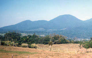 Cerro Montezuma volcano in the Tenorio volcanic complex is seen here from the SW. The Tenorio complex marks the SE limit of the Guanacaste Range, which extends NW towards the Nicaragua border. This complex of five volcanic cones along a NNW-SSE trend has a cluster of volcanic domes at its northern end. No confirmed historical eruptions have occurred at Tenorio. Despite the report of a volcanic eruption in 1816, the volcano was densely forested at the time of its December 1864 visit by Seebach.
Photo by Jorge Barquero, 1987 (OVSICORI-UNA).
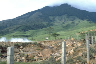 A geothermal area is seen here on the Miravalles SW flank in 1988. The edifice is one of five post-caldera cones constructed within the Pleistocene Guayabo caldera. Lava flows cover the W and SW flanks. A small steam explosion was reported in 1946 and a producing geothermal field is located within the caldera.
Photo by William Melson, 1988 (Smithsonian Institution)
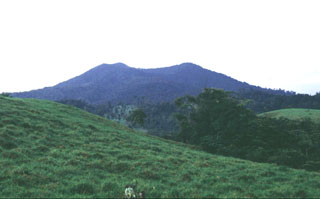 Platanar volcano is within of the Juan Castro Blanco National Park, located NW of the more well-known Poás volcano. Volcán Platanar and Volcán Porvenir were constructed along a N-S line in the western part of the park within Chocosuela caldera, which formed as a result of major explosive eruptions during the late Pleistocene.
Photo by Guillermo Alvarado (Instituto Costarricense de Electricidad).
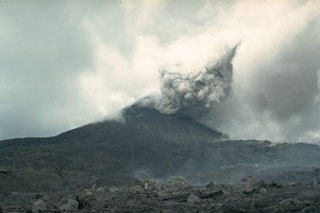 An eruption began at Arenal on 29 July 1968 with major explosions and pyroclastic flows that destroyed two towns and killed 78 people. Three new craters formed on the west flank. This 12 August 1968 view from the WNW flank shows an ash plume with part of the devastated zone in the foreground. Effusion of lava flows that began on 19 September formed an extensive lava field on the western flank.
Photo by William Melson, 1968 (Smithsonian Institution)
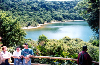 Botos is the southernmost of the three cones forming the summit of Poás volcano. Following cessation of eruptions at Botos, activity shifted NW to the now-active summit crater. The floor of the 1-km-wide crater is now covered by Laguna del Agua Fría.
Photo by Ichio Moriya (Kanazawa University).
 Minor phreatic eruptions ejecting material to heights of several meters were reported in March 1994. Two more phreatic eruptions were reported at the end of April, by which time the crater lake was nearly gone. Intense gas emission in the ensuing months caused health problems and severe economic losses in agricultural areas. Eruptions producing ash plumes that took place on 3 June and 9 July-5 August formed a small new crater. The crater lake (seen here 2 September 1994) returned, and minor phreatic eruptions occurred in October.
 Photo by José Enrique Valverde Sanabria, 1994 (courtesy of Eduardo Malavassi, OVSICORA-UNA).
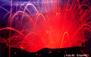 Strombolian explosions during the 1963-65 eruption ejected incandescent lava bombs from the crater, seen here in a time-lapse photo. Similar activity occurred in December 1963 and January 1964.
Photo by M. Esquivel (published in Barquero, 1998).
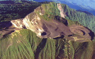 This photo shows the large scarp area that opens towards the NE (right) at the summit of Turrialba, the easternmost Holocene volcano in Costa Rica. The upper part of the scarp is partially filled by a smaller edifice with a roughly 1.3-km-wide crater, containing three smaller craters that erupted during the 18th-19th centuries. The walls of the two SW-most craters expose light-colored, hydrothermally altered rocks. Geothermal activity continues at these craters.
Photo by Federico Chavarria Kopper, 1999.
 The flanks of Von Seebach cone (upper right) are a result of tephra and acidic gases blown downwind from the lake-filled Cráter Activo (left). Steady trade winds from the NNE distribute gas from Active Crater to the SW, creating the "Dead Zone" that extends down the SW flanks to the upper right.
Photo by Eliecer Duarte (OVSICORI-UNA).
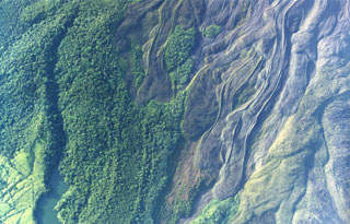 Lobate lava flows were emplaced down the northern flank of Arenal. Note the prominent flow levees and several kipukas (islands of forested land surrounded by lava flows). The eruption that began in 1968 covered much of the northern flank with lava flows. The lake at the lower left is named Peñaranda and lies at the edge of cultivated lands encroaching on the flanks.
Photo by Federico Chavarria Kopper, 1999 (courtesy of Eduardo Malavassi, OVSICORI-UNA).
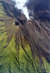 An active lava flow with small plumes rising from the margins can be seen at the upper right descending the Arenal NNW flank from the degassing Crater C complex on 29 June 1999. Below it, descending diagonally NE to the lower right, is another recent flow with clear lateral levees. The inactive crater to the left is Crater D, the pre-1968 summit crater.
 Photo by Federico Chavarria Kopper, 1999 (courtesy of Eduardo Malavassi, OVSICORI-UNA).
 A Strombolian eruption is seen here at Arenal on 15 June 1997. The oldest known Arenal products are about 7,000 years old, and the volcano was active for several thousand years contemporaneously with the older Chato volcano (lower right). A recent eruptive period began with a major explosive event in 1968, and frequent explosive activity and slow lava effusion continued through to 2010.
Photo by Olger Aragón, 1997.
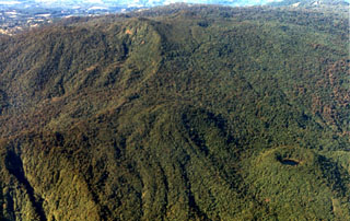 The summit area of Volcán Barva is composed of a series of overlapping cones with about a dozen vents. At the lower right is Danta cone with a small crater lake. Forest-covered lava flows can be seen to its left. Barva is the topographic high point of Braulio Carillo National Park.
Photo by Federico Chavarria Kopper, 1999 (courtesy of Eduardo Malavassi, OVSICORI-UNA).
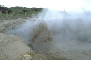 Vigorous mud eruptions occur at Las Hornillos thermal area on the W flank of Costa Rica's Miravalles volcano. A geothermal project in the 15 x 20 km Guayabo caldera (containing Miravalles) provides a major component of the electrical power needs of Costa Rica.
Photo by William Melson, 1988 (Smithsonian Institution)
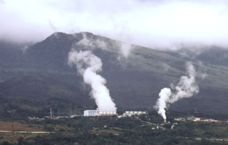 Steam plumes rise from power plants of the Miravalles geothermal project in 1998, which began production in 1994.
Photo by Paul Kimberly, 1998 (Smithsonian Institution).
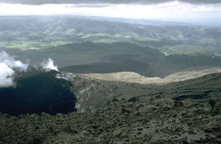 A lava flow issuing from Crater A is seen in April 1969. This crater was the source of the largest explosions at the onset of the eruption in July 1968. The distal end of the lava flow can be seen across the center of the photo. This flow initially traveled down the Río Tabacón on the NW flank, but later sent lobes over a broad area extending to the SW.
Photo by William Melson, 1969 (Smithsonian Institution).
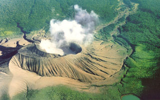 A steam plume rises from Cráter Activo of Rincón de la Vieja, seen here from the south with an acidic crater lake filling the innermost of two nested craters. Frequent eruptions and acid rain have kept the flanks of the cone unvegetated. Remobilization of fresh deposits has produced lahars down the Quebrada Azufrosa to the upper right.
Photo by Federico Chavarria Kopper, 1999.
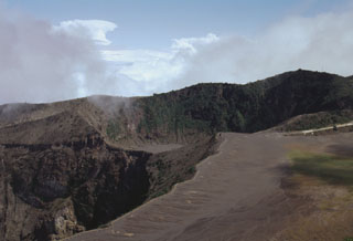 The infilled, 400 x 500 m wide Diego de la Haya crater in the background was the site of Irazú's first documented eruption in 1723. The eruption began on 16 February 1723, reached peak intensity in February and March, and continued sporadically until 11 December. Incandescent blocks and bombs were ejected, and ash fell on the cities of Cartago, San José, Barva, and Heredia. The active summit crater is to the lower left in this 1998 photo.
Photo by Lee Siebert, 1998 (Smithsonian Institution).
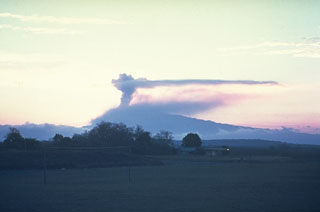 An ash plume above the summit of Irazú is seen in March 1963 from the old San José airport. Eruptions during 1963-65 were among the largest in historical time from the volcano. Intermittent mild-to-moderate explosive activity produced heavy ashfall that severely affected agricultural areas and caused economic disruption.
Photo by Dick Stoiber, 1963 (Dartmouth College).
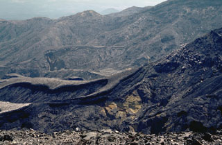 The Rincón de la Vieja SW flank contains a broad area almost entirely devoid of vegetation resulting from eruptions and acid rain. Steady trade winds from the NNE distribute acidic gases from Cráter Activo to the SW.
 Photo by William Melson, 1986 (Smithsonian Institution).
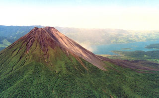 Below the vegetation on the NE Arenal flank is the A2 lava field. These voluminous flows cover the eastern flanks and are considered to have been erupted between about 1700 CE and the start of accurate historical records in Costa Rica in 1800 CE. The vegetation-free flank of the post-1968 cone form the right-hand side of the edifice, and recent lava flows from the 1968-2010 eruption are visible on the lower right-hand flanks with Lake Arenal in the background.
Photo by Federico Chavarria Kopper, 1999.
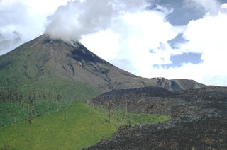 The dark lava flow at the lower right, seen here in June 1970, originated from Crater A on the lower western flank of Arenal in September 1968. Gas plumes rise from the B and C craters at the summit.
 Photo by William Melson, 1970 (Smithsonian Institution).
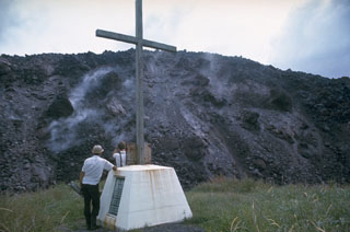 The margins of a lava flow descending the WNW flank of Arenal rise above a monument to victims of a powerful explosive eruption in July 1968. Lava flow effusion began on 19 September 1968 and by the time of this December 1968 photo had reached about 2 km from the vent on the lower west flank.
Photo by Dick Berg, 1968 (courtesy of William Melson, Smithsonian Institution).
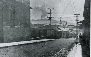 An ash plume above the Irazú summit crater is seen here in 1917 from the national theater in San José. All summit craters were reported to be active on 27 September 1917, after which activity steadily intensified. Ash fell in Curridabat on 18 November and again a month later, when ash also fell in Tres Ríos. On 6 January 1918 ashfall reached San José, Heredia, and Puriscal. Intermittent explosive activity continued until 1921, with an explosion on 30 November 1918 producing ashfall as far as Nicoya.
Anonymous, 1917 (published in Alvarado, 1989).
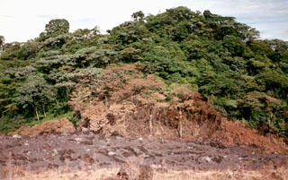 Vegetation was scorched along the margins of a pyroclastic flow that descended the Río Tabacón valley to a point only 400 m from the restaurant of the Tabacón Resort and Spa on 28 August 1993. Pyroclastic flows traveled down four valleys on the W-to-NW flanks on the 28th, and heavy ashfall broke tree limbs and damaged vegetation along a broad swath west of the volcano.
Photo by Erick Fernandez, 1993 (OVSICORI-UNA).
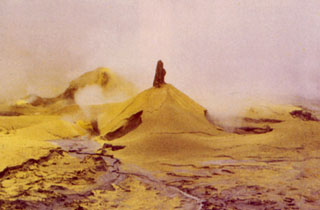 Small cones of mud and sulfur up to 3 m high formed on the active crater floor during 1989. Eruptive activity from June 1987 to June 1990 included phreatic explosions within the crater lake ejecting mud and sulfur, the formation of temporary small pools of sulfur-rich water, and the emission of sulfur flows up to 30 m long. Acidic gas plumes caused extensive damage to vegetation on the flanks.
Photo by Jorge Barquero, 1989 (Universidad Nacional Costa Rica).
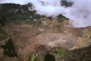 This area was impacted by an 8 December 1994 phreatic explosion is visible from the NW rim of Irazú's summit crater, seen here in 1998. The explosion originated from a geothermal area (lower right) on the upper NW flank and destroyed vegetation down to 2,500 m elevation. The explosion, which produced no juvenile material, created an irregular crater 60-80 m in diameter and sent ashfall to about 30 km distance. Landslides and lahars traveled down the Río Sucio drainage (right center).
Photo by Lee Siebert, 1998 (Smithsonian Institution).
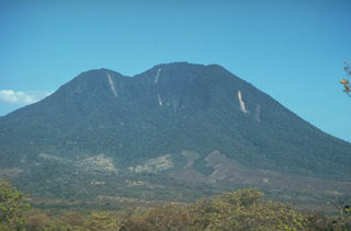 The SW side of Volcán Cacao, located at the SE end of the Orosí volcanic massif, is cut by an arcuate depression created during a massive slope failure in which the summit of the volcano was removed. The vertical light-colored stripes on the upper edifice are rockslide scars. The latest eruptive activity at the Orosí complex consisted of post-collapse lava domes and flows from Cerro Cacao.
Photo by Cindy Stine, 1989 (U.S. Geological Survey).
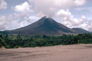 Arenal is seen here from the west in May 1981, with lava flowing from Crater C near the summit. The eruption began in July 1968 with powerful explosions from three craters on the west flank, with the strongest explosions from Crater A. In subsequent years activity migrated towards the summit and took place primarily from Crater C as well as from Crater D (near the former summit).
Photo by William Melson, 1981 (Smithsonian Institution).
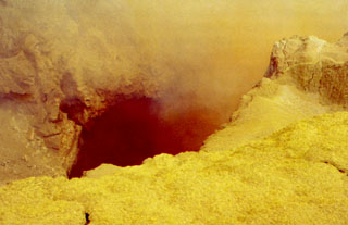 Yellow sulfur and other minerals precipitate around high-temperature fumaroles in the Poás summit crater. Fumarole temperatures approaching 600°C were recorded in 1988, several times higher than the melting point of sulfur. The ejection of sulfur clasts as well as small sulfur flows have been documented during several eruptions at Poás.
Photo by Jorge Barquero (Universidad Nacional Costa Rica).
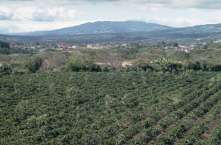 Poás volcano rises above coffee crops on the floor of the central valley of Costa Rica. Poás is the westernmost of three major volcanoes of the Cordillera Central that are easily visible from the capital city of San José and its outskirts. Ash deposits from their eruptions have contributed to fertile agricultural soils in the Central Valley. Poás National Park was established in 1971 and is one of the country's premier natural attractions.
 Photo by William Melson, 1993 (Smithsonian Institution).
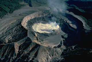 Steam pours from the surface of the hot, acid lake in the active vent of Poás volcano in this 1983 view from the south. The frequent eruptions from this lake in historical time make Poás one of Costa Rica's most active volcanoes and keep the flanks of the 1-km-wide, 275-m-deep crater vegetation free. Smaller eruptions produce geyser-like activity within the crater lake. Occasional larger eruptions completely eject the crater lake.
Copyrighted photo by Katia and Maurice Krafft, 1983.
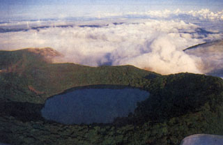 Botos cone forms the high point of the Poás volcanic massif. It was the eruptive focus prior to about 7,500 years ago, when activity shifted NW to the crater hidden beneath the clouds. The 1-km-wide crater contains a 400-m-wide lake.
Photo by S. Mora, 1988 (courtesy of Guillermo Alvarado, Instituto Costarricense de Electricidad).
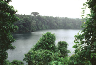 The Laguna Río Cuarto maar is at the northern end of a chain of vents extending to about 18 km from Poás volcano. The 600 x 750 m wide maar has a maximum depth of 66 m and the crater walls rise 4-20 m above the lake surface. The maar erupted through lahar and alluvial deposits on the coastal plain at an elevation of about 400 m above sea level.
Photo by Paul Kimberly, 1998 (Smithsonian Institution).
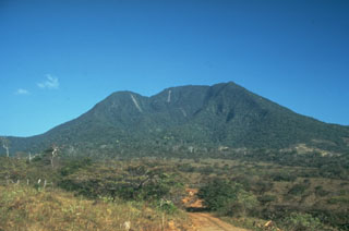 The highest peak of the Orosí volcanic complex is Volcán Cacao, which is seen here from the SW. The summit contains a scarp on the SW as a result of edifice collapse. Orosí is one of a cluster of four eroded and vegetated cones in the Guanacaste Range at the NW corner of Costa Rica.
 Photo by Cindy Stine, 1989 (U.S. Geological Survey).
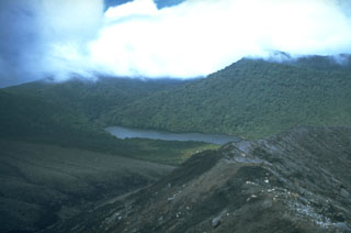 Laguna de Fria (center) is seen here from the west, along a ridge near Cráter Activo. It formed when meteoric water accumulated in a depression between overlapping cones of the Rincón de la Vieja complex. Rincón de la Vieja cone is to the upper right.
 Photo by Cindy Stine, 1989 (U.S. Geological Survey).
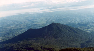 Cerro Congo is about 6 km N of Poás volcano and was is part of a N-S-trending chain of vents that extends into the Caribbean coastal plain in the background. The summit crater, located at the northern end of Poás National Park, opens towards the NW.
 Photo by Federico Chavarria Kopper, 1999 (courtesy of Eduardo Malavassi, OVSICORA-UNA).
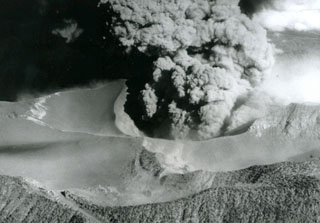 An ash plume erupts from the Irazú summit crater on 14 April 1964, about midway through a major explosive eruption that began in 1963. The ash-covered plateau to the left is Playa Hermosa, an older buried crater. The road to the summit is to the lower left. Heavy ashfall from the 1963-65 eruption was deposited across the Central Valley and caused major economic disruption.
Photo by U.S. Geological Survey, 1964.
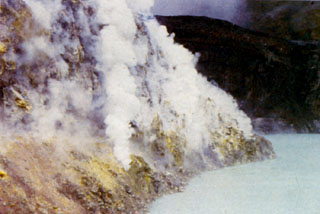 Gases emanate from fumaroles within the sulfur-lined wall of a lava dome at the bottom of the Poás active crater. The turquoise-colored crater lake is among the most acidic natural waters on Earth. The hot lake has been the source of frequent phreatic eruptions that produce plumes of steam, ash, and mud.
 Photo by Guillermo Alvarado (Instituto Costarricense de Electricidad).
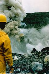 A geologist observes an ash plume rising 400 m above the summit crater of Poás on 25 April 1989. By 19 April, four days before this explosion, the crater lake had disappeared. In May 1989 ash plumes reached 1.5-2 km above the crater.
 Photo by Gerardo Soto, 1989 (Instituto Costarricense de Electridad).
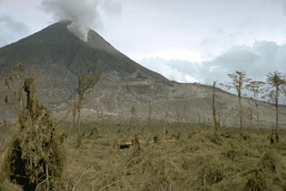 Three craters formed from the summit to the lower west flank of Arenal during the initial stages of a long-lived eruption that began on 29 July 1968. The lowermost crater (Crater A) is the near the center of this photo. Crater B is between Crater A and Crater C, which is producing a gas plume near the summit. Crater A was the source of the largest explosions, pyroclastic flows, and ballistic ejecta.
 Photo by William Melson, 1968 (Smithsonian Institution).
This is a compilation of Costa Rica volcano information sources, such as official monitoring or other government agencies.
| Volcanic Ash Advisory Center | |
|---|---|
| Washington Volcanic Ash Advisory Center (VAAC) | |
| - Washington VAAC Archive | |
| - Washington VAAC Notices | |